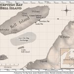
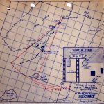
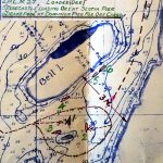
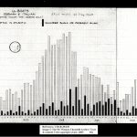
When World War II Came to Bell Island, Newfoundland When World War II Came to Bell Island, Newfoundland Bell Island Heritage Society Inc. & Shipwreck Preservation Society of Newfoundland & Labrador Inc.
Map of Bell Island in Conception Bay, Newfoundland. Bell Island is roughly 10 kilometres long by 3.5 kilometres wide, and is 5 kilometres offshore of Portugal Cove. The […]
This map of the second U-boat attack at Bell Island was drawn by Canadian Army Intelligence staff who investigated the sinkings. The map (marked SECRET) shows two ships […]
The Royal Canadian Navy (RCN) investigated the first U-boat attack and sinkings after September 5, 1942. This map came from RCN files on the sinking of SS Saganaga. […]
A chart provided by British Naval Intelligence to British Prime Minister Winston Churchill in 1945. The bar chart shows the estimated number of German U-boats operating in the […]