

1. Magog Across Time
Magog ca. 1838-1839
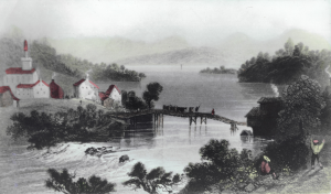
“Outlet of Lake Memphremagog” par William Henri Bartlett (1809-1854). Engraving published in 1840. Source: Magog Historical Society, PR002 fonds Bibliothèque Memphrémagog, album 2\photo # 208.
Magog is a city located at the outlet of Lake Memphrémagog in the Eastern Townships region of the province of Québec (Canada). It is this geographical location that inspired the two names attributed to the city over the years, “The Outlet,” and “Magog”. The latter name is likely a derivation of the Abenakis place names “Namagok”, (salmon trout) or “Mamhlawbagak” (vast lake).[1]
Indigenous peoples occupied the Lake Memphrémagog region from as early as the Paleoindian era (12000 to 8000 BC). Throughout the 17th and 18th centuries, this region was part of the Abénakis hunting territory. The start of colonisation in 1792, following the proclamation by Lieutenant-Governor Alured Clarke, and the creation of the Eastern Townships, hindered the free movement of the Abénakis hunters and gatherers. They did not occupy the territory on a permanent basis, thus facilitating the arrival of colonists and their progressive appropriation of the area. [2]
The first known fixture at the outlet of Lake Memphrémagog was a fish dam, probably constructed by an Abénakis nation. According to Nicholas Austin, a Quaker, this dam had been abandoned by the time of his arrival in 1795. Austin, an early pioneer of American origin, did not settle there and sold his land and the mill he had built on it to Ralph Merry III, originally from Massachusetts. The latter arrived at the Outlet with his family in 1799, and was a key figure in building the foundations of a nascent hamlet.[3]
As was the case with several Eastern Township villages, Magog was founded by pioneers of American origins, and would then go on to welcome British, Scottish, Irish and French-Canadian settlers.
These newcomers lived close to the Magog River which supplied the energy required by the first mill at the end of the 18th century and then factories at the end of the 19th century and the beginning of the 20th century.
The pictures and plans below illustrate the nature of the town’s population and the growth of Magog over a period of about one hundred years. And finally, because this exhibit deals with the evolution of education, we have circled the different schools on the various maps, in order to help you locate them within their surroundings.
Magog in Pictures
Magog ca. 1900
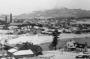
Source: Magog Historical Society, PR009 fonds Jacques Boivert.
Magog in 1929
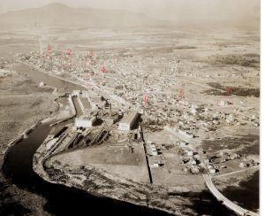
Aerial view of the town of Magog in 1929. (Click on the image to learn more about each of the schools that are circled and numbered) Source: Maurice Langlois Private Collection.
Magog via its Plans and Maps
Township of Magog, created in 1849
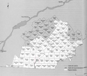
Map of the Eastern Townships indicating the concession year of each of the townships. The township of Magog is circled Source: Ministère des terres et forêts. (1973). Répertoire des cantons du Québec, Québec, cited in Jean-Pierre Kesteman & al., Histoire des Cantons de l’Est, Sainte-Foy, Institut québécois de recherche sur la culture, 1998, p. 94.
The Village of Magog in 1863
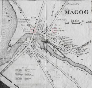
Circled: the Merry House and the Magog Academy. Source: Putnam & Gray (1863) Map of Magog, [photocopy] Magog Historical Society. Cartography Collection, Magog Historical Society, Magog
The Town of Magog in 1920
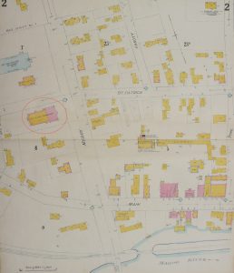
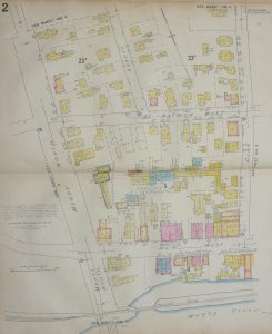
The corner of Merry and Main. Circled: the Sacré-Cœur (Ste-Croix) Convent. Source: Magog Historical Society, Cartography Collection\ Underwriters’s Survey Bureau ltd. (1920) Insurance Plan of Magog, Que. [Plan d’assurance]. 7 Sheets. Ottawa.
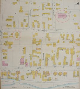
Downtown. Circled: The Magog Academy and l’Académie St-Patrice. Source: Magog Historical Society, Cartography Collection\ Underwriters’ Survey Bureau Limited. (1920) Insurance Plan of Magog, Que. 7 sheets. Ottawa.
Ville de Magog en 1951
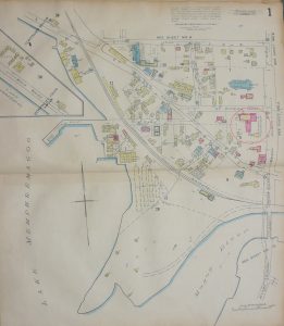
Point Merry. Circled: the Sacré-Cœur Convent..Source: Magog Historical Society, Cartography Collection\ Underwriters’s Survey Bureau ltd. (1951) Insurance Plan of the City of Magog, Que. [Plan d’assurance]. 14 sheets. Ottawa.
Corner of Merry North and Main Street. Source: Magog Historical Society, Cartography Collection\ Underwriters’s Survey Bureau ltd. (1951) Insurance Plan of the City of Magog, Que. [Plan d’assurance]. 14 sheets. Ottawa.
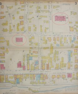
Downtown. Circled: the Magog High School and Saint-Patrice Academy. Source: Magog Historical Society, Cartography Collection\ Underwriters’s Survey Bureau ltd. (1951) Insurance Plan of the City of Magog, Que. [Plan d’assurance]. 14 feuilles. Ottawa.
[1] Pierre Paré, (1985), La toponymie des Abénaquis, Commission de toponymie: Gouvernement du Québec, p. 52 & 55.
[2] On the paleoindian, See Michel Gagné. (2015, mars). Culture Paléoindienne. In Canada Historica. from: https://www.encyclopediecanadienne.ca/fr/article/culture-paleoindienne/. On the occupation of the Lake Memphremagog region during the Paleoindian period and during the period from the 9th 11th 9th to the 11th century, see Paul Carignan, «The Abenakis – Past and Present», Stanstead Historical Society Journal, vol. 18, 1999, pp. 24-26. On the occupation of the Lake Memphremagog region during the colonial era, see Vincent O’Brien “An Address To The Stanstead Historical Society”, Stanstead Historical Society Journal, vol. 4, 1971, pp. 24-33. On the Abenakis, see Jeanne Morazain, “Sutton, terre des Abénakis”, Histoire Québec, vol. 19, no. 3, 2014, pp. 15-19.
[3] On the Outlet Foundation, see Maurice Langlois and Serge Gaudreau, Magog en mots et en images: 50 événements marquants de son histoire, Magog, the authors, 2018, p. 25 à 29 ; Harry B. Shufelt, Nicholas Austin: The Quaker…and the Township of Bolton, Knowlton, Brome County Historical Society, 1971, p. 142-144 ; William Bryant Bullock, Beautiful Waters, vol. 1, Ayer’s Cliff, Les Editions Pigwidgeon, 1985 (1926), p.57-62.