Crossing Cole Harbour: From Ferry to Dyke then Rail to Trail Crossing Cole Harbour: From Ferry to Dyke then Rail to Trail Cole Harbour Heritage Farm Museum
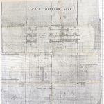
An 1880 plan titled “Transverse section of sluice frame,” showing a sluice gate of the Cole Harbour dyke, drawn by J. Leo. Liddiard.
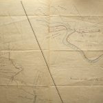
A map showing marsh lots, mostly belonging to the Bissett family. When the salt marsh was dyked, the resulting land was sold to local farmers, but it is […]
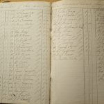
Many farmers from Cole Harbour were members of the Dartmouth Agricultural Society, and some familiar names can be seen here, on a membership list from 1886. J. G. […]
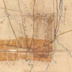
Section of “Plan of Two Hundred Acres of Land sold by Sir John Wentworth to Wm Allen,” showing Lawlor’s Point. The dots on the end of the point […]