Bedrock of Beachville: The History of Our Limestone Quarries Bedrock of Beachville: The History of Our Limestone Quarries Beachville District Museum
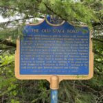
This plaque was installed on the grounds of Sweaburg Central School on County Road 14, southeast of Woodstock by Ontario Heritage Trust’s for their Provincial Plaque Program. This […]
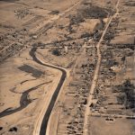
The most severe flood recorded along the Thames River occurred in April of 1937. In response to this devastation, Beachville opted to alter the course of the Thames […]
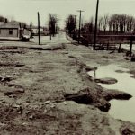
Looking south down the flooded sideroad, this image shows the damage caused to the office and the company homes. John Downing’s family home (later the Beachville Museum) is […]
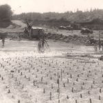
In this image, a layer of rock has been cleared of overburden, and workers plan to blast through the “cap rock,” which lies over the desired limestone reserves. […]
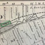
At the centre of this map is the Village of Beachville. Above the Canadian National Railroad tracks (marked C.N.R.) are lots numbered 18 to 22. Lot 18 is […]
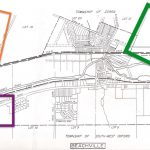
When looking at this diagram, note the river zigzagging at a diagonal and the location of the railroad (marked by a black and white band) running above the […]
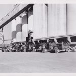
Beachville’s roads were paved in the early 1920s, which sparked the introduction of trucks being used at the quarries. Trucks became useful at the pits and plants since […]
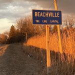
A road sign greets visitors to Beachville as they head east on Beachville Road (County Road 9). The sign acknowledges the village’s title as “The Lime Capital.” Given […]
The image shows Carmeuse Lime Limited‘s present-day limestone operation in Beachville at sunset, seen from the southeast on County Road 6. The Beachville White Lime Company initially mined […]
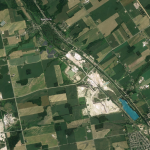
This image shows the scale of the Beachville quarries. The Village of Beachville is marked at the top (in the east), and the Town of Ingersoll is labelled […]