The History of Ste. Marie II The Story of Ste. Marie II Museum of Ontario Archaeology
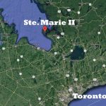
This map shows the location of Ste Marie II on Christian Island in association to modern cities such as Toronto.
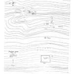
ca. 1980’s A number of known archaeological sites scatter across the island, with the potential for many others waiting to be uncovered. This topographic map shows a handful […]
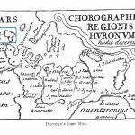
Date: 1660 With invaluable help of this map, a number of Jesuit Fathers starting with P. Chazelle first attempted to identify the remnants of Indigenous villages and European […]
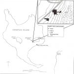
In 1991, Northeastern Archaeological Associates carried out additional excavations at the site. They concluded that the site was the location of a village that refugees established on their […]
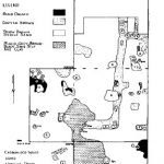
Kidd’s excavations focused on the corner bastions. The southwest bastion was 14 feet long by 11 feet wide, with 18 inch thick stone walls. The footing extended 4 […]
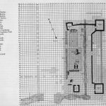
Date: 1965 The construction trench for the building became increasingly apparent with the excavation. Approximately twenty-two feet of continuous trench was uncovered outlining the corner of the structure […]
ca. 1965 Four major features were uncovered, including the partial, well-preserved but mostly charred remains of a building against the north wall, among which was found a rich […]
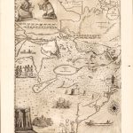
ca. 1657 Map of North America, from Newfoundland to Lake Superior, and from the Gulf of St. Lawrence to Chesapeake Bay. A small map of Huronia is presented […]
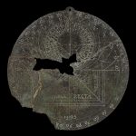
Date: 1595 The Christian Island Astrolabe was found in the 1920’s at Ste. Marie II by Elijah Monague, a local Ojibway man. The astrolabe is one of three […]