1
The North Shore, Nova ScotiaWhen the Acadians arrived in this area of Nova Scotia around 1710, they were helped by the indigenous Mi'kmaq. The settlements were small and scattered and depended on whatever food they could find or produce on their newly dyked and cleared land, such as some grain and berries, which was supplemented by fish. The cut timber provided houses and fuel. Eventually they traded, especially with the French at Louisbourg, until they were expelled from the area by the British in 1755.
1770 saw the Montbeliards (from near the Swiss border) and French Huguenots settling in parts of the area, brought here under the auspices of Colonel Des Barres who in 1773, for his considerable services to the British Government, received 20 000 acres (8000 hectares) of land around Tatamagouche. This he divided into usually 100 acre (40 hectare) lots, hoping to establish an English "manorial" system by renting them to settlers. In fact, this system delayed settlement in the Tatamagouche area, as pioneers wanted ownership of the land on which they laboured, so it was not until his death that his estate sold off the lots and the Tatamagouche area started to develop.
Elsewhere, settlers (the Scots especially) arrived in the areas around River John, Earltown, New Annan, and Wallace. Used to scratching a living from the Highlands of Scotland, some managed to survive in the higher country, but it did not lead to adaptable farming practises, and after a few years, the land failed to produce good crops. They had to move, develop new farming methods or finding other means of earning money.
Wellwood Waugh came from Scotland to Prince Edward Island and moved to Tatamagouche around 1776. He was able to lease 1600 acres of prime land including the land around the Waugh River. He was to become a leading citizen in the area and encouraged the clearing and cultivating of the land.
The Campbells were another family to exert a major influence on Tatamagouche, with Alexander, in 1823, buying land to the west of the French River, where it joins the Waugh River. This was the first land bought from the DesBarres estate in Tatamagouche, a 'good buy' for it included navigable water, access to sawmills, and the timber rafted down the river from the interior. It was to become the site of his shipyard enterprise.
2
Close Up of the Area Investigated, North Shore, Nova Scotia, Canada2010
North Shore, Nova Scotia, Canada
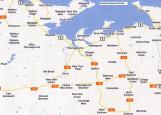 Credits:
Google Maps
3
Earlier, land outside the estate had quickly been acquired and settled, so good farming land was in short supply.When the British Army Officer Joseph Frederick Wallet Des Barres died, the thousands of acres of land he had been given as a reward for his various services to the British Crown became available. Instead of leasing the 100 to 150 acre (40-60 hectare) farm lots from his estate, settlers could acquire the land rights, enabling families to move into the Tatamagouche area.
These families expanded, land changed hands, and names of landmarks were altered, all making research today quite difficult. Early writings and records referred to properties by owners' names - repeated use of christian names or a nickname adds to the confusion. These properties were sold over the next 100 years. Family names were repeated but sometimes acquired different spellings. Brooks and streams changed their names, and even different sections of the same brook had another name.
Memories are surprisingly short, and had it not been for the dedicated writings and research of Frank Patterson and Roy Kennedy, now both deceased, much of the history would have been lost.
Most of the places mentioned during this exploration of industries are shown on this map.
4
Satellite Image of the Northumberland Strait, River John to Wallace, Nova Scotia, Canada2005
North Shore, Nova Scotia, Canada
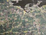 Credits:
North Shore Archives - Creamery Square Heritage Centre (CSHC)