1
The taming of the Kootenay River has had a huge impact on the development of the Creston Valley - and the occasions when the river broke free from its controls have made indelible marks on the memories of the Valley's residents. Reclamation has left a physical legacy as well: evidence of the changes the river has undergone remain throughout the Creston Valley, as a testament to the decades of struggle, setbacks, and ultimately, success.Cyril Colonel, who knows most of these indications of the Valley's history, offered to show us where they were. On a cold, windy morning in November, 2003, we set out on what would be a six-hour tour of the Valley.
2
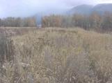
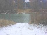
A dyke on Duck Lake21 November 2003
Duck Lake, north of Creston, BC
3
We started our tour by heading out to Wynndel, taking Channel Road, which parallels the old Goat River Channel, to the south end of Duck Lake. We drove west along the dyke that separates the main part of Duck Lake from the Creston Wildlife Area's nesting area; this was one of the dykes built to preserve the marshes. Cyril ran a dragline and helped build this dyke in 1970. This photo shows the dyke, with Duck Lake on the left and the nesting area on the right.4
Granary on Duck Lake Road21 November 2003
Duck Lake, north of Creston, BC
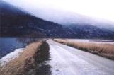
5
We came back to Channel Road, then turned west again to drive along the dyke that separates the Creston Wildlife Area's nesting area from the farmland that was reclaimed as the Duck Lake Dyking District in 1950. The dyke ended at Duck Lake Road, and we continued west, with Cyril stopping to point out these granaries. They obviously pre-date the dykes that were built in 1950; they were built on stilts to keep the grain dry during floods.6
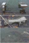
Hunting lodge of an American duck hunting club.21 November 2003
Kootenay River, near Creston, BC
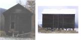
7
A little farther west along Duck Lake Road, Cyril stopped so we could hike into this hunting lodge. Built by an American duck hunting club, it was here when Cyril came to the Creston Valley in 1944 and is still in use today. It, too, shows the effects of the frequent flooding of the Valley before reclamation took place; the floor of the lodge is nearly twenty feet above the water level. Even now, the lodge is not protected by dykes; when the river rose over sixteen feet in 1997, this lodge would have been very nearly flooded.8
The old Lewis Island ferry landing21 November 2003
Kootenay River, near Creston, BC
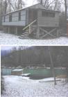
9
Duck Lake Road ends at this old ferry landing on the East Channel of the Kootenay River. Across the river is Lewis Island, or Six Mile Slough as it is called now. Today, the area is part of the Creston Valley Wildlife Area, which maintains the landing. Before reclamation, though, it was a prime area for hay cuts and cattle pasturage, and was reached by a cable ferry.10
Remains of the Lewis Island Ferry21 November 2003
Kootenay River, near Creston, BC
11
These are the remains of the Lewis Island Ferry. It was a rustic cable ferry, built of logs with a plank deck, and powered by a flathead Ford V-8 engine (the engine mount is visible in the top photo), and the transmission (centre) and rear-end differential out of a truck. A cable, attached to the shore on each side of the river, wrapped around a three-foot cable pulley (bottom photo) and pulled the ferry from one side to the other.12
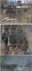
Remains of a dragline on a Creston Dyking District dyke.21 November 2003
Creston Dyking District, near Creston, BC
13
We headed east again, following Duck Lake Road, about half-way across the flats. There, Cyril turned south on Abbott Road and we climbed up on the dyke to see the remains of this old dragline. The operator's cab has long since disappeared, but the tracks and turning mechanism are still intact (top photo); the counterweight (centre), used to balance the machine when it was lifting a load of dirt, is still there, although it has trees growing through it; and the name plate, announcing that this is a Bucyrus Erie dragline, is still very readable (bottom).14
Looking north along the Creston Dyking District dyke.21 November 2003
Creston Dyking District, near Creston, BC