14
Looking north along the Creston Dyking District dyke.21 November 2003
Creston Dyking District, near Creston, BC
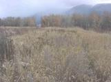
15
The dragline, Cyril says, was kept on top of this dyke so that it could quickly repair damage to the dyke. Because of the sharp curve in the Kootenay River at this point, the dyke washed away badly; the dragline was in frequent use, scooping mud from the bottom of the river and piling it on the back of the dyke. It's because of this, Cyril says, that this dyke is so wide - it's well over fifty feet wide at the top.16
Wynndel Pumphouse21 November 2003
Wynndel, north of Creston, BC
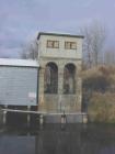
17
Rejoining Duck Lake Road, we continued east onto Lower Wynndel Road, then turned onto Pump Road to take a look at the Wynndel Pumphouse. This one was built in 1945, and replaced the original one that nearly washed away in 1938. It is near here, in fact, that the Creston Dyking District dykes broke in both 1938 and 1948. The pumps themselves are located in the small room at the top of the pumphouse; it was built high to avoid damage to the pumps during floods. This was a wise precaution: Cyril remembers there being fourteen feet of water on the farmland here, in 1948.18
Wynndel pumping installations21 November 2003
Wynndel, north of Creston, BC
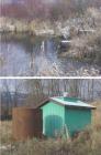
19
Like all the pumphouses on the Creston flats, the Wynndel one has culverts running through the dyke to discharge the water into the river (top photo). In 1997, a second pumphouse (bottom) was installed, because the original one couldn't remove enough water fast enough to prevent extensive crop damage when fourteen inches of rain fell in June of that year. It is hoped that the second pumphouse will prevent a similar event in the future.20
False Mouth, between the Kootenay and Goat River channels21 November 2003
False Mouth, near Creston, BC
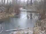
21
Cyril's contacts with local farmers proved invaluable, as it meant we could drive onto private property to take a look at False Mouth. This is a short channel between the Goat and Kootenay Rivers; before reclamation took place, the channel would be flooded during high water, and the two rivers would actually be connected. Today, a dyke separates the two at the west end of False Mouth.22
River markers at the old West Creston Ferry landing.21 November 2003
West Creston, west of Creston, BC
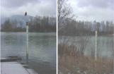
23
Several people had told us about the towers at the West Creston Ferry, which were marked in feet to gauge the water level. The ferry, and those towers, are long gone, but these markers have taken the place of the towers. They are marked to show the height of the water above "0 level" - 1739.32 feet above sea level. Cyril explained that this is the lowest water level allowed under the Libby Dam agreement.24
Pump installations on Reclamation Dyking District.21 November 2003
Reclamation Farm, near Creston, BC

25
This is one of the few original pumps still being used in any of the four dyking districts in the area (top photo). This pumping station sits behind the dyke that divides the Reclamation Dyking District in two. The discharge culverts (centre) are surrounded by a concrete structure to keep beavers from blocking them. The original wooden culverts through the dyke (bottom) were replaced only a few months before our visit. The pumphouse here is another of the green structures like that at Wynndel.26
Looking north towards French's slough.21 November 2003
West Creston, west of Creston, BC
