14
Nevertheless, work on the diversion went ahead. Draglines dug the new channel for the Goat River, then opened the bank of the Goat and allowed the water to flow into the Kootenay.With the problem of the Goat River solved, work could begin on the dyking of the Kootenay River.
15
Building dyke on Creston Dyking District.1935
Creston Dyking District, near Creston, BC
16
Unlike the Reclamation Farmers Association, most of the people who bought land in the Creston Dyking District were local residents. They purchased the land for $30 an acre and paid cash; this provided the money to fund the dyking operations.An anniversary edition of the Creston Review newspaper, published on May 10, 1951, described the work: "A bed of blue clay subsoil had to be unearthed for the entire 14 or more miles, up to 100 feet in width. The heart of the dyke is the core ditch, dug six feet deep and four feet wide down the centre of the dyke and filled with clay soil, rolled and kneaded and pressed in order that there would be no seams."
Dirt was packed on top of this core using cats, scrapers, and draglines.
17
Men dyking the Kootenay River.1935
Creston Valley, BC
18
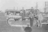
Harry and Clarence Christenson had brought a caterpillar tractor ("cats") with them from Idaho in 1929, and, by 1935, had purchased other cats as well as scrapers. Grant Christenson recalls that when the dyking was completed on Reclamation Farm, "our cats and scrapers came over and helped reclaim this dyking district. That's how Dad and Harry got that land that I used to farm out here. Instead of paying them in cash they took land."19
Building dykes on the Creston Dyking District.1935
Creston Dyking District, near Creston, BC
20
"My father was a personal friend of the dyking commissioner. The dykes had to pass an inspection as to height, width at the top, et cetera. It was only natural that my father accompany the commis- sioner. After walking along the dykes for a mile or so, the commissioner stopped, turned to my father, and said 'Why don't we get...off this thing before we fall off it!' In other words, it was so narrow. During 1936 the dykes were widened and much improved."- Bill Constable
21
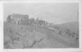
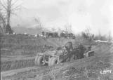
Working on diverting the Goat River into the Kootenay River.1935
Goat River, south of Creston, BC
22
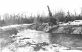
Dragline dredges had been used in every reclamation attempt since 1893."It's [a dragline] very much like a backhoe. It has the tracks, and you sit in here, and this [the boom] is on the front of it. The bucket goes down into the dirt, into the ground, and picks it up, and then this [the boom] swings around and drops it off again. Just like a backhoe, but it's bigger."
- Margaret Berg
In 1934-1935, for the first time, cats and scrapers were used, and there arose a great controversy over which was the better method.
23
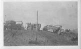
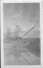
Diversion of the Goat River.1935
Goat River, south of Creston, BC
24
Detailed records, and races between crews on the two different types of equipment, clearly declared the winner: the cats and scrapers could build a far more solid dyke, at a lower cost, than the draglines.25
Curly Pridmore operating a dragline at the Goat River diversion.1935
Goat River, south of Creston, BC
26
The Nick's Island Dyking District was also established at this time, with the dykes being built in 1936 and the first crop going in in 1937. Poole Construction Company, whose dragline had been working on Reclamation Farm, also built the Nick's Island dykes. Dr. Brunner, who owned the 2,000 acres of Nick's Island, gave the southern half to Poole Construction in exchange for the work on the dykes.Future events would show that the Nick's Island dykes were the exception to the generally-held belief that dragline dykes were inferior to those built with cats and scrapers. Bill Piper points out that, because Nick's Island was an island, with two channels for flood waters to flow through, its dykes would be subject to less pressure; undoubtedly, though, the careful engineering of these dykes was also a factor.
27
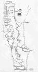
A map of dykes along the Kootenay River1935
Creston Valley, BC