1
20 Mile CreekHelen Moore,
B.C. Naturalist, June (Summer) 1989
When it is a hundred in Hedley we head up the creek. The creek is cool and damp. It runs between the rock walls of a box canyon. The contrast with the heat in town is notable. The town is surrounded by rock formations which hold the heat and throw it down on the houses.
To understand the geography cup your right hand and place the slightly curved fingers of your left hand almost against your right palm. Your left hand is Stemwinder Mountain. Your right thumb is Nickel Plate Mountain and your right fingers Aberdeen Ridge with the creek flowing between your two hands. The town lies between the base of your two thumbs.
This is the dry interior zone, altitude at valley floor just under 2000 feet (1760 meters) with ridges going up another 2000 feet. Average precipitation is 10 - 15 inches. The tree coverage is predominantly Douglas Fir and Ponderosa Pine. The ground coverage is sparse.
Hedley Creek (formerly Twenty Mile Creek because it was 20 miles from Keremeos) flows north-south, emptying into the Similkameen River. At the turn of the 20th century, this creek was a route north to the Kettle Valley Railway - a line that runs from Summerland to Princeton and to Penticton.
The mining companies dammed the creek for a water supply by flume to the reduction mill and later installed wood stave pipe for a domestic water supply. This meant that a road existed, and bridges, to allow easy access up the creek during the life of the mines.
The creek has twice flooded: in 1948 and in 1972. The latter flood wiped out the dam and all the bridges. The Hedley Improvement District was forced to switch to deep wells for the town water supply.
Before 1972 the road up the creek led from the end of Scott Avenue at the base of Stemwinder. After 1972, Highways created a road on the east side of the creek reached from Webster. Town planning in Hedley has more than once been initiated by Mother Nature.
A walk up the creek then begins at Hospital Hill, so called because that's where the hospital was located before patients went to Princeton), this where the splendor of nature unfolds along the trail with Mariposa Lily, Balsam Root, Rocky Mountain and Dwarf Juniper along the path. After a left turn at the first road, the road passes two tailing sections, which nature has reclaimed from the remnants of the mining industry, is now abundant with Red Cedars, cottonwood, grasses, berries, butterfly's, squirrels, marmots and birds.
In less than half an hour you have walked as far as the "Mascot turn off". This is where the road turns right and zig zags up the hill to the site of the Old Hedley Mascot Gold Mines mill (unreachable now).
Or walk straight on and you enter the canyon park of the creek. It is a foot path from here on. The next section of the walk takes you to where a bridge was washed out and now all crossings must be forded. You can see the wooden bridge planking still intact but lying up on the bank across from you.
Often along the path relics of the creek's mining past will show themselves - the wooden water flumes, miner's ground dwellings, scraps of metal and tins. Evidence that the path is regularly enjoyed by people is the ongoing maintenance of the rock walls that are built up along the path to prevent the rocky slopes from crossing the walkway.
As it were with the Similkameen People, the creek is place of renewal and reverence. Deep in the canyon of Hedley creek, a monk sought meditation and seclusion for nearly ten years; observers came from across the world to visit and bring offerings of peace.
Today the Twenty Mile Creek /Hedley Creek continues to be a special place to those who live near it - it is used daily by many people and maintained by many dedicated users. Townfolk have worked together several times, over many years to build the "third" bridge; not one has survived the velocity of the creek during the spring runoffs. Try at Ted might!
Be forewarned if you take to the trail - wear a good pair of shoes, you can drink from the creek if you like, and definitely take a dip in the swimming hole at the washed out Third Bridge; bring your camera, you'll need one to take photographs mountain goats and deer and borrow a town dog to ward off the cougars and bears!
Hedley Heritage Museum Society
2
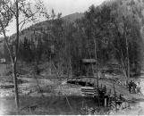
Crossing 20 Mile Creek into Camp Hedley ca. 1895Late 19th Century, Circa 1895
Hedley, British Columbia
 Credits:
Hedley Heritage Museum Society
3
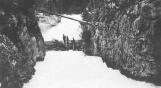
20 Mile Creek /Hedley Creek Log Jam20th Century, Circa 1900 - 1920
20 Mile Creek / Hedley Creek
 Credits:
Hedley Heritage Museum Society
4
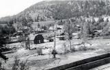
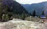
Hedley Flood 1948 Looking Across Twenty Mile Creek20th Century, 1948
Hedley, British Columbia
 Credits:
Hedley Heritage Museum Society
5
Hedley Flood 1972 Haynes Street, North, FacingTwenty Mile Creek20th Century, 1972
Hedley, British Columbia
 Credits:
Hedley Heritage Museum Society
6
Hedley Flood 1972 Webster Street Bridge20th Century, 1972
Hedley, British Columbia
 Credits:
Hedley Heritage Museum Society
7
Trail Foot Path21st Century, Circa 2012
20 Mile Creek / Hedley Creek
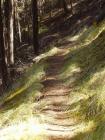 Credits:
Hedley Heritage Museum Society
8
20 Mile Creek Trail & Rock Wall ca. 201221st Century, Circa 2012
20 Mile Creek / Hedley Creek
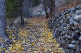 Credits:
Hedley Heritage Museum Society
9
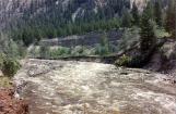
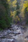
Twenty Mile Creek Canyon ca. 201221st Century, Circa 2012
20 Mile Creek / Hedley Creek
10
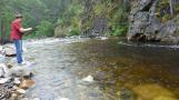
Reed Fishing up 20 Mile Creek2011
20 Mile Creek / Hedley Creek
 Credits:
Hedley Heritage Museum Society
11
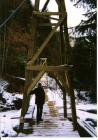
20 Mile Creek /Hedley Creek, Third Bridge ca. 200221st Century, Circa 2002
20 Mile Creek / Hedley Creek
 Credits:
Hedley Heritage Museum Society
12
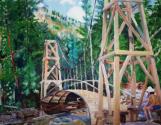
20 Mile Creek / Hedley Creek, Third Bridge painting21st Century, Circa 2005-2008
20 Mile Creek / Hedley Creek
 Credits:
Hedley Heritage Museum Society
L Derrick Collection
13
Twenty Mile Creek/ Hedley Creek Ted's Bridge Part I ca. 200621st Century, Circa 2006
20 Mile Creek / Hedley Creek
 Credits:
Hedley Heritage Museum Society
Wit's End Productions
14
Twenty Mile Creek/Hedley Creek Ted's Bridge Part II ca.200621st Century, Circa 2006
20 Mile Creek / Hedley Creek
Credits:Hedley Heritage Museum Society
Wit's End Production