1
The position of Tatamagouche on the Northumberland Shore1955-1965
Tatamagouche, Nova Scotia Canada
 Credits:
Beth Carruthers
2
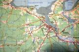
This simple map showing the site of Tatamagouche, was part of a brochure about the North Shore - the sea-side highway - The Sunrise Trail' . The pamphlet emphasized the Festival of the Arts, with a large 'background' photograph of the Tatamagouche Common, showing it covered in tents, and people watching an event. The Festival was held during the 1950's and 60's, and was said to be 'one of Nova Scotia's most popular, most talked about, and most anticipated annual events. It draws many thousands of visitors from both the United States and Canada, to the quaint village of Tatamagouche...' It was partly due to the success of this event and the ability of the local residents to run it, that led to later development plans for the village.So it was that many years later, various members of this small community decided that Tatamagouche, with its population of about 700, once again needed to be 'put on the map' -With other organizations to help and advise a number of plans and ideas were looked at. The following is the story of what happened over the intervening years and how Creamery Square became the focus of attention.
3
Looking across Tatamagouche to the Bay and Malagash20th Century
Tatamagouche, Nova Scotia Canada
 Credits:
North Shore Archives
4
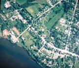
This aerial picture follows the Waugh River as it flows west past Tatamagouche to the bay where a battle took place between the French and the English in the 1700's. In the distance is the Malagash Peninsular.5
Tatamagouche and area.21st Century.2010
Bayhead to Brule via Tatamagouche, Nova Scotia, Canada
 Credits:
Google Maps
6
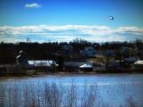
Visitors crossing into Nova Scotia from New Brunswick tend to follow the major Trans Canada Highway, route 104, to Antigonish and Cape Breton thereby missing the delights of the North Shore, where there are large areas of secondary forest, farms, quiet flowing rivers, the occasional settlement and picturesque sea bays.Winters are severe on roads and it is a constant problem to keep the main roads well maintained. Many side roads are still gravel and potholes are persistent. 2012 saw much work done to better road surfaces, especially on Highway 6 between Amherst and Pictou - there are still poor patches but the general improvement makes travel for residents and tourists much more pleasant!. The link road 326, from Highway 6 to the 311 Truro road is now good.
Residents put up with the problems because they love the area, and visitors have usually found the scenery and their contacts with the local population,well worth the effort to get here.
Passing through Tatamagouche, Creamery Square is visible from the main road and is indicated 'C 'on the map
7
Creamery Square from the air21st Century Circa 2000
Tatamagouche, Nova Scotia Canada
 Credits:
North Shore Archives
8
The Creamery Square complex on the lower left by the water is not difficult to find, being near the main route through the village. The Train Station Inn is on the trail and closeby for anyone wishing to stay longer and have a unique experience eating and sleeping in converted railcars.The 'village Square' one of the Four Squares suggested for development (see later) is seen here to the right and below Main Street. The green area on one side of the Creamery Road, belongs to residents in the immediate vacinity and being well maintained creates a park-like approach to the Square.Much former farm land in the area has reverted to forest or is left as hay meadow, but people are returning to the land and starting organic small holdings. As in many rural areas, keeping the young in the area is a problem, and Tatamagouche is no exception.The local High School produces students achieving exellent results - so they tend to go to university and do not return until older and more appreciative of what the region has to offer This is made up for by the enthusiasm of the 'incomers' .People are coming from abroad, and other provinces, delighted to find workable land, and prepared to try their hand at a varierty of farming enterprises; International computer outlets and skilled tradesmen find work here, and the retired bring their lifetime of skills.
9
Site of Creamery Square from across the Waugh River21st Century, 2006
Tatamagouche, Nova Scotia Canada
 Credits:
Creamery Square Association
10
Viewed from across the Waugh River, the Feed Mill (Grain Elevator) and adjoining structures are clearly visible. The Farmers' Market is in place but the Ice House has not yet been moved.The Creamery is visible and a small part of the Shed building. The road- Creamery Road - leads up to the main Highway 6 running between Pictou and Amherst.Once the Ice house was moved, the deck outside the new Farmers' Market was built with access to the water . Both the Waugh River and the French River are beautiful for kayaking, with quiet backwaters where eagles watch from the trees and beavers sometimes slip away.
11
Former use of the Creamery Site20th Century 1900
Tatamagouche, Nova Scotia Canada
 Credits:
North Shore Archives
12
In 1900 the last large ship to be built in Tatamagouche was finally launched from just east of what is now the Creamery Square. In the foreground are the tracks of the former Intercolonial Railway (the Short Line - 1887 - 1986) which ran from Pictou, through Tatamagouche, to Wallace and on to Pugwash and then to Oxford Junction where it connected with the Canadian National Railway, with links to Truro and Halifax. This finally closed in 1986, the track later to become part of the Trans Canada Trail (known locally as The Butter Trail)The Bonyman factory seen in the background burnt down in 1922 but the Bonnyman (the spelling changed) family are still active in the community, owning the elegant house at the top of Creamery Road, and running a Tea House there.
So with the site cleared after 1922, the land was available for Alexander Ross to build his Creamery in 1924.
13
The Tatamagouche Creamery20th Century. Circa1927
Tatamagouche, Nova Scotia Canada
 Credits:
North Shore Archives