1
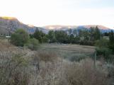
No photographic records of the water system for Mill have been found, therefore, archaeological research and comparisons to similar mills were used to establish the most probable scenario.About 80 metres upstream from the Mill are the remnants of a dam which would have been constructed to create a mill pond.
2
Looking east over what was once the Mill pond; the dam would have been in the line of trees.7 October 2012
Grist Mill at Keremeos Creek, Keremeos British Columbia, Canada
 Credits:
Jim Millar
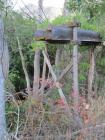
3
Remnants of the dam with the Mill behind5 October 2012
Grist Mill at Keremeos Creek, Keremeos British Columbia, Canada
 Credits:
Jim Millar
4
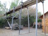
Entrance to the reconstructed flume, the dam would have been this height.5 October 2012
Grist Mill at Keremeos Creek, Keremeos British Columbia, Canada
 Credits:
Jim Millar
5
View west of the flume to where the dam would have been6 October 2102
Grist Mill at Keremeos Creek, Keremeos British Columbia, Canada
 Credits:
Jim Millar
6
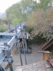
Detail of the flume as it approaches the Mill5 October 2012
Grist Mill at Keremeos Creek, Keremeos British Columbia, Canada
 Credits:
Jim Millar
7
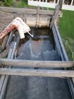
The major reason why the Mill stopped production in 1895 was not having the water rights to Keremeos Creek. In 1980, when the Province was restoring the Mill, they opted not obtaining the water rights but rather installed a cistern and pumps to supply water up to the rebuilt flume.8
Pipe system used to pump water into the flume; note control gate behind.5 October 2012
Grist Mill at Keremeos Creek, Keremeos British Columbia, Canada
 Credits:
Jim Millar
9
Detail of the water control gate in the flume.6 October 2012
Grist Mill at Keremeos Creek, Keremeos British Columbia, Canada
 Credits:
Jim Millar
10
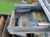
Detail of end of the flume showing water outlet to the wheel.6 October 2012
Grist Mill at Keremeos Creek, Keremeos British Columbia, Canada
 Credits:
Jim Millar
11
Over flow chute diverts excess water from the flume5 October 2012
Grist Mill at Keremeos Creek, Keremeos British Columbia, Canada
 Credits:
Jim Millar
12
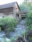
The water wheel and flume are located on the south side of the Mill; Keremeos Creek passes on the north side. The flow of water to the wheel must be controlled to prevent damage and provide a controlled amount of water to the wheel.13
The Keremeos Creek passes the Mill to the North. The creek is near the high water mark.18 May 2010
Grist Mill at Keremeos Creek, Keremeos British Columbia, Canada
 Credits:
Jim Millar