1
By the opening of the 16th century, the abundance of fish and fur in North America was well known. Ships came from many countries to catch some of the amazing abundance. They took their catch back to the European coastal cities for sale.France and England were at war for many years over possession of much of the east coast of North America, including Acadia.
Ownership changed hands several times between 1600 and 1760.
Acadia was a battlefield for North American possession for over 150 years.
Both sides wanted to strengthen their claim to the land by having settlements in Acadia.
The people, coming from France to settle in Acadia, were from the western lowlands.
French permanent settlements began along the Bay Of Fundy.
By 1686 there were perhaps six hundred people living and farming in Acadia.
The expansion of Acadian agriculture was confined chiefly to marshland areas.
They were repeatedly urged by the government to farm the upland areas but the rich marsh soil drew the Acadian's interest.
2
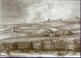
Image of Fort Lawrence, present day Amherst, in 175518th Century, Circa 1755
Fort Lawrence, Cumberland County, Nova Scotia
 Credits:
Wallace and Area Museum
3
As Acadian families grew bigger it was necessary to expand the cultivated space found along marshes and rivers in Nova Scotia. Low crop yields because of continuous use was to be expected. There is evidence of the settlers expanding out from Port Royal, along the Bay of Fundy, to both shores of the Minas Basin and into Chignecto. It's also possible they expanded down along the Northmberland Strait. Acadians living along the Nothumberland Strait were criticized for not farming uplands and sometimes called lazy; other times they were called "Farmers of the Water".Rich soil and good production provided a coarse marsh hay which enabled them to feed thier animals and have small gardens.
4
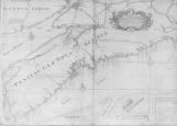
1750 map of Nova Scotia, clearly showing the Chignecto to Cobiquid road (Amherst-Truro)18th Century. Circa 1750
Acadia
 Credits:
Wallace and Area Museum
5
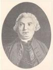
Lt. Governor of Nova Scotia, Charles Lawrence; The Deploration took place under his command8th Century, Circa 1753
Nova Scotia
 Credits:
Nova Scotia Archives
6
The trail from Cobiquid (Truro) to Tatamagouche, rough in places, followed the Chigonois River18th Century, Circa 1710
Earl Town, Colchester County, Nova Scotia
 Credits:
Charlotte Moody
7
What happened? In July, 1755, because of political decisions resulting from, among other reasons, the British fear that the local Acadians would help any invading French force, an order was given by Lieutenant-Governor Lawrence and his Council to proceed with a plan to disperse the Acadian settlers living in Nova Scotia.The reason given was the Acadian's refusal to take an oath of allegiance to the British King. The orders were given to Colonel Monckton at Fort Lawrence, near present day Amherst, who passed them along to men in his command.
There were (estimates) of about 7000 Acadians living in Nova Scotia in 1755.
A plan was drawn up by Surveyor-Gen. Charles Morris for the efficient removal of the Acadians. The plan was to bodily, without warning, seize the French and deport them to places where they could not provide assistance to the French in Acadia.
On July 31, Lawrence wrote Colonel Monckton ordering him to carry out the deportation. He gave specific instructions to destroy the Acadian settlement at Tatamagouche.
The deed was carried out by new England volunteer, Captain Abijiah Willard. He was dispatched with men and sealed orders to go to Tatamagouche and carry out the task. They crossed Cumberland County from Fort Lawrence to Cobequid (Truro).
On August 13, he met up with a Capt. Lewis and Ensign Willard three miles from Cobiquid (Truro) on the road to Tatamagouche. There, they opened their orders from Col. Monckton. Willard said he was shocked to read his orders.
The next day Willard and Lewis arrived in Tatamagouche and called a meeting of all inhabitants for the morning of August 15, 1755.
8
Re-enactment soldiers of the Deportation period18th Century, Circa 1755
Remsheg, one of 19 ways to spell the Mi'kmaq name for the village in Nova Scotia now Wallace
 Credits:
David Dewar
9
The Acadians at Remsheg were removed that same day - August 15, 1755. Captain Lewis and Ensign Willard were dispatched to a village 15 to 17 kilometres to the west called "Remsheg", to capture the settlers and burn their homes.They proceeded - Lewis and twenty soldiers with canoes by water, and Willard and twenty soldiers by land. On August 16, 1755 Lewis and Willard returned to Tatamagouche with three families after having burned the settlement at Remsheg.
Capt. Willard read his orders to the assembled Acadians in Tatamagouche and then proceeded to burn the village. He gave the men of the village the choice whether to bring the women and children along to Cobequid or to leave them there. It was decided to leave the women and children.
10
Rich marshland at Remsheg Bay, first seen by Acadian farmers in about 171021st Century, Circa August 2010
North Wallace Road, Wallace Bay Cumberland County, Nova Scotia
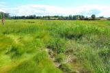 Credits:
David Dewar
11
Dewar River at extremely low tide. Thought to be site of Acadian Floating Bridge on old French Road18th Century. Circa 1710
Dewar River, Malagash, Cumberland County, Nova Scotia.
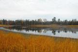 Credits:
Jim Reeves
12
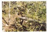
Re-enactment of twenty British and New England soldiers on a march through the woods to Remsheg
13
Steven's Hill from the east bank of the Dewar River; Acadian home foundations and two wells found18th Century. Circa 1710
Dewar River, Malagash, Cumberland County, Nova Scotia.
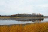 Credits:
Jim Reeves
Linda Reeves
14
Acadian expulsion orders being carried out in Remsheg15 August 1755
North Wallace Road, Wallace Bay Cumberland County, Nova Scotia
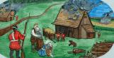 Credits:
Barbara Clark