1
Map of 17th Century France showing the area in Normandy from which many of the French came to Acadia18th Century
France
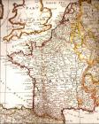 Credits:
Wallace and Area Museum
2
The dyke and aboiteau were used by the Acadian settlers to protect and improve the fertile marshland.First, the Acadians would build a dyke to surround a desired marsh area, to protect it from tidal flooding. These dykes were all constructed by hand, using simple hand tools, sleds and sometimes oxen. Some dykes could be several kilometres in length. Normally they would be built about 3 metres above the high water mark. The average daily tide rise in this area is 1.5 to 2.5 metres, but can be much higher in the spring and fall. Places had to be found to excavate fill to build the dyke. In today's construction, these areas are called "borrow pits". Aerial photos show many pits along dyke construction, so the material was always near to the construction site.
Nex,t the farmers would install an aboiteau in the low areas along the dyke. An aboiteau is a simple wooden valve that uses a wooden flap to control watter flow. It was installed to allow rain water or snow melt water to drain from the land, to help leach out the salt from marsh soil, making it very productive farm soil. The leaching process takes three to four years.
When a breach of a dyke happens, through storms or floods, it was devastating for farmers to lose large sections of their crop land.
3
Diagram of a working dyke18th Century,
North Wallace Road, Wallace Bay Cumberland County, Nova Scotia
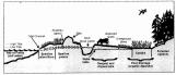 Credits:
Nova Scotia, Ducks Unlimited Amherst
4
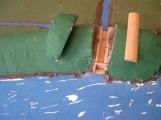
Model of working aboiteau; in the foreground are drainage ditches sloping to the aboiteau at the top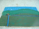
5
Model of a working aboiteau18th Century design. Circa 1720
Tuttle Creek, Wallace Bridge, Cumberland County, Nova Scotia.
 Credits:
Jim Reeves, model maker
Zella Perry, Photographer
6
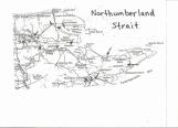
Map of North Cumberland County area with evidence of Acadian habitationModern map of 18th Century Acadian life
Northumberland Strait, Cumberland County, Nova Scotia.
 Credits:
David Dewar
7
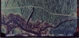
Aerial photo of Wallace Bay including Akerly Brook and Long Brook21st Century
 Credits:
Nova Scotia Geomatics Centre, Amherst, NS
8
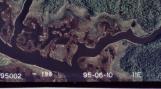
Aerial photo of Wallace Bay, Akerly Brook on left and Long Brook on right21st Century, Circa 2005
Long Brook, North Wallace, Cumberland County, Nova Scotia.
 Credits:
Geomatics Centre, Amherst, Nova Scotia
9
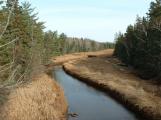
Dyke at Akerly Brook - note the small amount of farmable land secured by building a dyke18th Century. Circa 1730
Akerly Brook, Wallace Bay, Cumberland County, Nova Scotia
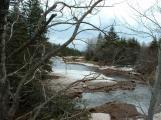 Credits:
David Dewar
10
A west bank river dyke with a small amount of secured farmland at Akerly Brook18th Century. Circa 1730
Akerly Brook, Wallace Bay, Cumberland County, Nova Scotia
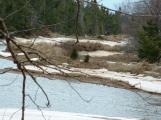 Credits:
David Dewar
11
Dykes along Akerly Brook18th Century, Circa 1730
Akerly Brook, Wallace Bay, Cumberland County, Nova Scotia
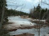 Credits:
David Dewar
12
Dykes visable on both sides of Akerly Brook18th Century, Circa 1730
Akerly Brook, Wallace Bay, Cumberland County, Nova Scotia
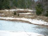 Credits:
David Dewar
13
Akerly Brook; shows the large amount of work needed to secure just a small amount of farmable land18th Century, Circa 1730
Akerly Brook, Wallace Bay, Cumberland County, Nova Scotia
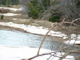 Credits:
David Dewar
14
Long Brook dykes along each side of the brook, capturing only a small width of fertile soil18th Century, Circa 1730
Long Brook, North Wallace, Cumberland County, Nova Scotia.