1
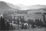
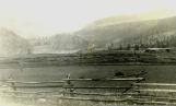
Overlooking the Kettle River as it flows east, downstream toward Midway1920-1930
The Kettle River Valley
 Credits:
Kettle River Museum
2
Imagine how the early settlers would have seen their new land for the first time as they arrived so long ago. They settled along the Kettle River and its broad valley, and up creeks and streams into the benchlands. They found timber for building and grasslands ready to till. Follow the countless miles of split-rail fences that defined their homesteads."In 1858 there were 500 miners engaged in placer mining on Rock Creek, a stream tributary to the Kettle River. Placer mining on the creeks was the only kind of activity in the country at that time, before people settled down in later years to till the soil. The amount of gold recovered on Rock Creek was considerable, judging by the acres of rocks that were moved and washed by hand. The activity by this large number of men ended when gold was discovered in the Cariboo country."
- from "A Harvest of Memories" by Bill Hatton
3
Follow the Kettle River Valley and its tributaries from Bridesville east to Boundary FallsThe Kettle River and its tributaries
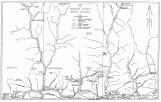 Credits:
Drawn by J. A. Millican, 1958
Boundary Historical Society 11th Report, 1988
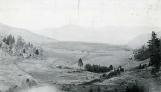
4
Looking west up the Kettle River over Midway, formerly Eholt's Farm.1896
The Kettle River Valley
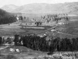 Credits:
Kettle River Museum
5
Homesteading the Bubar RanchIt was 1891 when Mr. C. W. Bubar arrived with his family in the Boundary district and settled in their log home located on the north side of the Kettle River about a mile west of Ingram Ford. Mr. Bubar had first seen the property in the spring when the hills were green and the creek was running full - down the hillside between two benched. It was this sight that made him want the property.
The following was found among the papers of Mr. J.M. Bubar, describing leaving Penticton for the final leg of the journey from England... "Now came the most serious part of our journey - transferring seven people with one team and a saddle horse about 100 miles over hills and high mountains. Loading grub and bedding and six persons into the heavy wagon and with one person riding the saddle horse, we set forth..."
And on their arrival at their new home many days later... "We kept on till dark following a hogback which was called a road... Next morning on we went up the same hogback till we thought we would never get to the top. But every mountain has a peak and soon we were in bunchgrass country and fairly level. It was beautiful country - wood in the south and grass and water everywhere... Soon we dropped down to Mary Ann Creek and after crawling up a long hill we slipped down to Myers Creek. McMynn's ranch came in sight and then crawling up a long slope we could see the Kettle River down below. At Rock Creek we turned east and soon were fording the river to our future home."
- from "The Bubars Coming West", by Beatrice (Bubar) Weed and Wesley Weed, Boundary Historical Society 7th Report, 1976
6
Crossing the Kettle River at Bubar Ford; bridges were few and far betweenCirca 1900
The Kettle River Valley
 Credits:
Kettle River Museum
Bubar family photograph
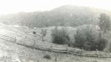
7
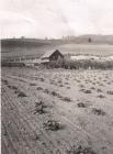
Following fencelines along the valleyCirca 1910
The Kettle River Valley
 Credits:
Kettle River Museum
Donated by Nora Eveleth, 1978
8
Jackson Ranch"...a suitable ranch was then bought at the mouth of Myers Creek. This ranch had a large timbered flat with a big creek suitable for irrigation.
In the spring of 1890 father returned to Kamloops and on June 25th married Miss Agnes B. Tannahill, a native of Scotland. After purchasing a team, wagon and other necessary equipment for their new home, they proceeded to Mission (now Kelowna) where everything but the horses were loaded on an Indian scow to be transported down the Okanagan Lake. Father and Mother rode the horses down the east side of the lake and met up with the Indians and their wagon at what is now the city of Penticton.
They loaded their wagon and headed south through the Okanagan Valley to what is now the village of Osoyoos. Here it was necessary to ford the lake at that narrow neck of land, proceed over the Anarchist Mountain to the Kettle River valley. They reached their new location after traveling many miles over bad roads, trails and numerous swollen streams. In spite of all the hardships these hardy pioneers developed a fine ranch which is still in the family, presently being operated by the youngest son, Robert."
- from "John Robert Jackson", contributed by the Jackson Family, Boundary Historical Society 4th Report, 1968
9
The J.R. Jackson Ranch on the Kettle River just west of Midway1910
The Kettle River Valley
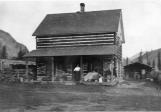 Credits:
Kettle River Museum, Sonny Jackson collection
Donated by the estate of Mike Downing, 1977
10
Into the benchlands above the Kettle River1900-1910
Benchlands of the Kettle River Valley
 Credits:
Kettle River Museum
Donated by Nora Eveleth, 1978
11
View of the Hopper Ranch on Ingram MountainCirca 1910
Benchlands of the Kettle River Valley
 Credits:
Kettle River Museum
Donated by Fred Lander, 1977
12
Sidley's Ranch"From its first small beginnings, Mr. Sidley's ranch has gradually been increased in size until today its area is about 2,000 acres, including arable land equal to any in the district, pasture lands, and some fine timber country, upon which fir, pine and tamarack, much of this timber suitable for saw logs, are to be found in abundance. The timbered lands are generally of good soil, having open stretches of up to 50 acres each among the belts of trees, making them well-suited for dairying, especially as numerous springs provide plenty of water. In the neighbourhood are ranges fit for either sheep or cattle, so that either dairying or raising cattle or sheep for the butcher can be followed to advantage, specially now that markets are becoming easily accessible. Heretofore, outside of a small market at Camp McKinney and Midway, there has been little demand for dairy produce, but this drawback is being removed as the mining towns and camps of the Boundary increase in population and provide a market for these and other products.
...This land is under cultivation this season for the first time, and oats and barley sown on the sod have grown and yielded so well that its fertility was evident to all who saw the crops growing. Mr. Sidley had under cultivation this year about 400 acres, of which 150 acres were in grain, 12 acres in roots, and the remainder fallow for next season's cropping. These fields are all fenced, as too is all the rest of the ranch upon which there are in all about 10 miles of rail fencing."
- from "R.G.Sidley's Ranch", the Midway Dispatch, September 29, 1902.
13
The Bodman Place on Rock MountainCirca 1910
Benchlands of the Kettle River Valley
 Credits:
Kettle River Museum
Donated by Mary Rock, 1978
14
A Kettle River Valley homestead in the early days1900
The Kettle River Valley
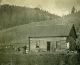 Credits:
Kettle River Museum
Donated by Nora Eveleth, 1978