1
Fred was back in Robson again, anxious to sail the lower lake after spending so much time at Arrowhead and surrounding waters. Overwhelmed by all the heavy industrial domination from Nakusp to the reaches of the North Arm, he was delighted to see a change evolving where land was chosen to embrace agrarian activity.In mountainous regions, it is understandable that narrow valleys aren't seen as suitable landscapes for agricultural endeavors. On the one hand acreage is kept minimal but on the positive side adequate rainfall, moderate climate, workable soil, and transportation facilities, are ideal conditions for the production of fruit and vegetables. Not having to rely upon irrigation systems would give Arrow Lakes' farms a leg up on dry areas such as the Okanagan. Investors keen on finding new ways to bring good returns in an emerging economy started to form land companies. Assisted by the government's attitude towards opening up BC to immigration, they got huge blocks of real estate for under $2.00 an acre (.40 hectare) then resold the lots for up to $150.00 per acre. (.40 hectare)
2
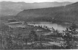
Robson, 1910Circa 1909-1910
Robson, Arrow Lakes, BC
3
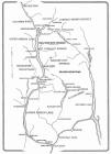
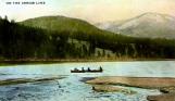
A view of the Kootenay, Slocan and Arrow Lakes running parallel, north and south, demonstrates the difficulty of east-west transport in the southern interior of BC. While steamboats moved easily on the wide lakes, railways encountered deep ravines, rivers and mountain passes on all routes leading from the prairie to the coast. The richness of the resources harvested from these lake areas made it profitable for companies and individuals to thrive in a previously harsh and wild country.4
Arrow Lakes Map20th Century
West Kootenay
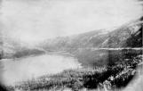
5
Syringa CreekSyringer Creek, Lower Arrow Lakes
6
Gliding along through the ever widening channel, Fred could not only see the right-away of the Columbia & Western Railway as it slowly climbed higher towards the summit of the Monashee Mountains but he also felt the vibrancy of an emerging province being connected from the Rockies to the coast. Transportation was so important to all aspects of development and the maintenance of a single-minded society.7
Kettle Valley Line, Arrow Lakes1908
Lower Arrow Lake
8
An encroaching forest and near total abandonment of the town of Brooklyn, forgotten after the completion of the Columbia & Western Railway, gave testimony to the vulnerability of instant towns. Once the crews moved on, the population dropped dramatically leaving empty hotels and bars. Since this was 99% of the infrastructure no one could survive. The empty buildings were now being torn down with the lumber carried away and used for structures in new settlements like Deer Park.Deer Park town site was purchased by Gov. Mackintosh in 1898. It was an early site frequented by indigenous people for the purpose of obtaining venison. Hundreds of deer foraged on this flat making their capture simple. In later days "Dad Allen" used to winter his large pack of horses and mules there, awaiting the spring rush of prospectors.
With 200 acres (80.94 hectares) of land surveyed, a new purpose for the soil was envisioned.
9
Deer Park1900
Deer Park
10
Fred soon realized that land, determined feasible for settlement and agricultural use, was at a premium. Most of the shoreline properties were shallow and others often sloped radically or receded out in various benches. Old Dog Creek was the exception. After Fred Nash had done some clearing, planted fruit trees and cultivated small crops, others joined, noting the success he had obtained. One of the others was the Western Land Co. of Winnipeg; who sent Frank Siemens out to buy almost all Fred's land, had it subdivided and put on the market. Enjoying perhaps the best climate on the whole lake, Dog Creek was flat, warm and ideal for fruit growing. But there was one thing that needed to be changed. "Dog Creek" was not an acceptable name. After holding a contest, "Renata" meaning reborn, was chosen as the new designation.11
Renata 1910circa 1908
Lower Arrow Lake

12
The Minto's nose was heading almost due north now after leaving Renata, its passengers gazed into a wide expanse of water much different than the more confined valley previously experienced. The sheerness of the mountains convinced Fred there would be little in the way of human habitation for several miles along this broad waterway.After a couple of hours and nearly 25 miles (40.25 km) of smooth water, Fred finally caught sight of rising smoke on the west shore. He gestured to a fellow passenger showing excitement at the prospect of engaging civilization. On approach it was clear several men were busy building a wharf while a tug and pile-driver were also being operated. Only after a nerve-racking landing at a very small T-shaped wharf did Fred learn that this dock had been floated up here from the old town of Brooklyn.
Following a survey that had been done at Killarney in 1908, the new name of Edgewood was given to the area, while the Inonoaklin Valley, that leads to a trail running to the Okanagan, was usually called Fire Valley. It was a concern in Nelson that sold its rights to the site of Killarney to the Western Canada Investment Company owned by the Ford brothers. Joe Rollins built the first house but it was apparent from the rush of settlers moving into other parts of BC that Edgewood would see the same influx.
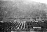
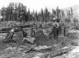
13
Clearing land in Edgewood, BC1908
Edgewood, Lower Arrow Lakes
14
Little time was lost at Edgewood, and the boat now headed north into an ever narrowing waterway. Passengers seemed a bit puzzled by the distant scene where the mountains appeared to block the lake completely. Fred who had gone for coffee was startled by the sound of the steam whistle, coming so quickly. The boat was pulling into Needles. When the Columbia Valley Land Co. obtained title to land in the Whatshan Valley high above Needles, about forty families moved in to start farming. Seen as a bit of a scam due to the fact that the soil was rocky and lacking a good supply of water, this venture was a questionable endeavor.Fred learned that Joe Crowell of Nakusp, who was agent for CVL Co. was pushing for a store to be built at their waterfront property of Needles. Puzzled by the odd name given the landing, he later was told this referred to a couple of spits of land that projected out into the lake.