1
Glimpses of Osgoode Township . . 150 Years of History1977
2
In 1791, Canada was divided into Upper and Lower Canada, and John Graves Simcoe (called the Father of Upper Canada) was the first Lieutenant-Governor. The first Executive Council meeting was held in Kingston, 3 July, 1792, and one of its members, the Honourable William Osgoode, Chief Justice of Upper Canada, was the man whose name was later given to the Township of Osgoode.Osgoode Township was surveyed in at least three stages: some before 1795 when there was a request for land along the Rideau; some after 5 October, 1796 when an act was passed to complete as much as remains in Osgoode, Wolford, etc.; the remaining part after 1822 when an advertisement was put in the Upper Canada Gazette that sealed proposals would be received for the completion of the survey of several townships in the Johnstown District. The survey was to be paid for in land - a percentage of the land surveyed - after one seventh was taken out for the Crown and one seventh for the Clergy Reserves. The patent would be given without fee and no settlement duty would be required.
In the years from 1799 to 1827, numerous grants of land in the Township were made by the Crown, according to the Ontario Provincial Government Index to Land Patents. Most of this was given out to sons and daughters of United Empire Loyalists; some was in recognition of military services; and some was to new settlers. Few of the names appearing on the Index were listed in the 1842 census of Osgoode Township, thus it would seem that many did not become permanent settlers but sold their holdings.
Archibald McDonnell, according to the inscription on his tombstone in St. Catherine's Cemetery in Metcalfe, was the first settler to come into Osgoode with his family - in March 1827. The tombstone of William York, in the Methodist Cemetery in Metcalfe, states that he was the first settler in the Township.
The 1842 Census shows a population of 1279 for Osgoode Township. By 1861 this figure had increased to 4,332 and in 1871 there were 4,267 persons living in the Township. In the next 100 years this figure had risen to 7,757 and the latest figure is 8,957 in 1976.
Ref: Glimpses of Osgoode Township - 150 Years published by the Osgoode Township Historical Society in 1977.
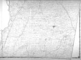
3
1897 Map of Carleton County1879
4
The H. Belden & Co. Historical Atlas of Carleton County - 1879 stated the Township of Osgoode, judged by its extent, coupled with its chances of development within the next decade, as compared with that development in its own case, and the cases of the other municipalities of the County for the past ten years, Osgoode may fairly be considered a leading Township.Belden went on to say that in extent it is the greatest, containing by actual measurement 90,894 acres of land; being 7,321 acres more than Gloucester, the second in size, and nearly four times the area of Torbolton, the smallest; while in wealth and population it is third, being behind Nepean and Gloucester in both, though following Gloucester very closely in the former, the value of real property being $ 1,135,806, which is exceeded in Gloucester by only $369,638, although the population is only as 1 to 2.12, being 3,685 in Osgoode, and 7,815 in Gloucester. As compared with Nepean, the wealth and population of each bear nearly the same ratio to each other, each being a trifle less than double in Nepean what it is in Osgoode.
5
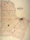
1879 Map of Osgoode Township showing land owners1879
6
The Township of Osgoode was surveyed in at least three stages: some before 1795 when there was a request for land along the Rideau; some after 5 October 1796 when an act was passed to complete as much as remains in Osgoode, Wolford, etc.; the remaining part after 1822 when an advertisement was put in the Upper Canada Gazette that sealed proposals would be received for the completion of the survey of several townships in the Johnstown District. The survey was to be paid for in land - a percentage of the land surveyed - after one seventh was taken out for the Crown and one seventh for the Clergy Reserves. The patent would be given without fee and no settlement duty would be required.In the years from 1799 to 1827, numerous grants of land in the Township were made by the Crown, according to the Ontario Provincial Government Index to Land Patents. Most of this was given out to sons and daughters of United Empire Loyalists; some was in recognition of military services; and some was to new settlers. Few of the names appearing on the Index were listed in the 1842 census of Osgoode Township, thus it would seem that many did not become permanent settlers but sold their holdings.
7
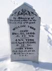
Gravestone for William and Ann York1860
8
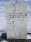
It is interesting to note that the gravestone of William and Ann York reads "In Memory of the first settlers in the Township of Osgoode". The same claim is made on the gravestone of Col. Archibald McDonell.Research has shown that both families set out from Cornwall, Ontario on the same day in 1827 and both had the goal of settling on their newly granted land in the wilderness Township of Osgoode.
9
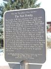
First Settlers . . The York Family Plaque1827
10
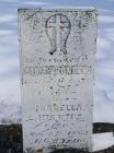
Gravestone for Isabella McDonell . . Wife of Col. Archibald McDonell1863
11
The gravestone of Col. Archibald McDonell has the added inscription "He was the first with his family led into the wilderness of Osgoode in March 1827"12
Gravestone for Col. Archibald McDonell1853
13
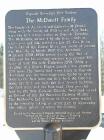
First Settlers . . The McDonell Family Plaque2000
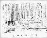
14
Settlers First Cabin1830