1
Tsunami 192922 November 2005
2
A tsunami is a natural occurrence consisting of a series of waves generated when water in a lake or the sea is rapidly displaced on a massive scale. Earthquakes, landslides, volcanic eruptions and large meteorite impacts all have the potential to generate a tsunami. The effects of a tsunami can range from unnoticeable to devastation. The term tsunami comes from the Japanese language meaning harbour (tsu) and wave (nami). The term was created by fishermen who returned to port to find the area surrounding the harbour devastated, although they had not been aware of any wave in the open water. Tsunamis have been historically referred to as tidal waves because as they approach land they take on the characteristics of a violent onrushing tide rather than the sort of cresting waves that are formed by wind action upon the ocean. However, since they are not actually related to tides the term is considered misleading.3
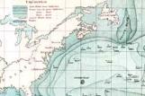
Travel times and speeds1968
Dominion of Newfoundland
4
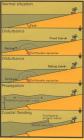
The 1929 tsunami approaching Newfoundland indicates that the period of each pulse was about 10 minutes and the wavelength was about 20 km. A tsunami begins to slow down as it interacts with the ocean floor. It begins to lose energy through frictional losses with the ocean floor and in its final stages as it approaches a shoreline it builds in amplitude again much like an ocean swell approaching a beach. When a tsunami arrives at a shoreline it often is first seen as a withdrawal of the sea: a rapid drop in sea level. The positive pulse may first arrive as a breaking wave then surge inland as a steadily rising sea level: a positive rapid rise of sea level. A tsunami wave also has considerable energy or momentum as it arrives at a shoreline. If the shoreline is a cliff, the wave will just reflect and go back out to sea. However, if the shoreline is a low, flat, barrier beach the tsunami's momentum can carry it a considerable distance inland before its rise against gravity takes its energy and it must flow back to the sea. The run-up distance, the distance from the normal high tide line, was as much as one to two kilometres in the 1929 tsunami.5
Memorial University of Newfoundland2000
St. John's, Newfoundland, Canada
6
Dr. Michael Staveley, a professor at Memorial University of Newfoundland, teaches in the Department of Geography.7
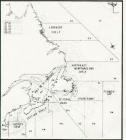
Burin Open to the Atlantic Ocean1980
Burin, Dominion of Newfoundland
8
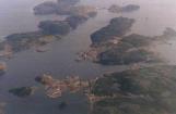
An Ariel Photo of Great Burin Island"The MUN Gazette" volume 37 Number 9, Dr. Michael Staveley, Department of Geography, Memorial University of Newfoundland:
"The Burin earthquake took place deep in the earth below the north wall of the canyon (St. Lawrence Canyon). The earthquake shook up all the sediment lying on this steep slope. I think it was the second biggest earthquake in Canada, at that time around 7.2 on the Richter scale. The shaking of the earth triggered an enormous mudslide and this mudslide went down the slope at a very fast speed and displaced a huge amount of submarine material, maybe as much as 20 cubic kilometres. Then the water surface dropped- it created a hole in the ocean and the water naturally rushed in to level it off and once it levelled off, it pushed out again - that would be the tidal wave."
9
Laurentian Slopes1992
Dominion of Newfoundland
10
Monday, November 18, 1929, the Grand Banks Earthquake occurred at 1632:00.2 EST (2032:00.2UT); the recently recomputed hypocentre of Dewey and Gordon (1984) is beneath the Laurentian Slope at 44.691 degrees North, 56.006 degrees West with a focal depth of 18.6 km.11
Submarine Telegraph Cables27 January 2005
Atlantic Ocean
12
Dr. Staveley said, "The event took about two hours. The waves in some areas may have reached about 30 feet. It was a nice, clear November evening, then at 7:30 the water hit. Because it was dark- not many people saw the water recede from the harbour - a sign that the tsunami was going to hit." Dr. Staveley also stated that the reason that they can be so precise about the timing of the Burin earthquake is due to the usage of submarine cables."During those days, most communication was by submarine telegraph cables. The cables connected New York and Boston to Europe. There were about 12 main cables, which curved around the Grand Banks and stretched fro 3,000 miles continuously. The landslide during the earthquake snapped them and told us how big the mudslide was - the cables were very precisely timed to the second. When the cables broke the clock stopped," he explained. "So we know exactly when they broke and we get a good feeling of the speed of the mudslide."