1
These maps and aerial photographs of Bendale over time reflect Bendale's evolving landscape from rural to urban.2
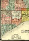
Scarborough Map1850

3
Scarborough Map1860

4
Scarborough Map1878
5
Scarborough Map1910

6
Scarborough Map1932

7
A map showing the Bendale area1970
Bendale, Scarborough, Ontario, Canada
8
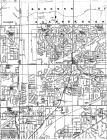
A map showing the Bendale area1996
Bendale, Scarborough, Ontario, Canada

9
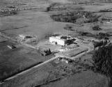
Scarborough General Hospital, looking northwest from McCowan and Lawrence1954
Bendale, Scarborough, Ontario, Canada
10
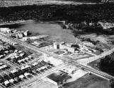
This photograph and the following ones of Lawrence Avenue at McCowan Road reveal the stunning changes to Bendale's landscape over fifteen years. In the 1954 photo farmland stretches out in all directions like a huge patchwork quilt. By 1969, with the exception of the wide path of the hydro fields, the suburban neighbourhoods appear fully developed. The growing Scarborough General Hospital, as well as apartment buildings and strip plazas are striking additions to the area's main roads.11
Scarborough General Hospital looking northwest from McCowan and Lawrence1969
Bendale, Scarborough, Ontario, Canada
12
Scarborough General Hospital looking northeast from south of Lawrence.1969
Bendale, Scarborough, Ontario, Canada
