1
N.W.M.P.10 August 1954
Climax, Saskatchewan, Canada
2
Letter to the Editor:In reference to your notice of an award from the American Association for State and Local History, mainly for marking the N.W.M.P. Trail from Wood Mountain to Fort Walsh, under the auspices of the Saskatchewan History and Folklore Society, this recognition should be shared with about 500 people and organizations who contributed expense money for research and for making the markers and also the time and labor for installation.
The largest individual money contribution was $1100.00; the smallest 25 cents. There was also financial assistance from local clubs and organizations, R.M.'s, and the province. Small committees of from 3 to 8 transported and planted the markers without charge, that people 500 to 1000 years from now, when reading the stories associated with this trail's early history, may know its precise location.
True, the trail varied at times as it wound around sloughs and hills, taking longer roundabouts in wet weather and short cuts when it was dry, but we marked the most travelled routes, as nearly as we could, with the assistance of early maps and many old timers.
Provincial Archives Branch of the Legislative Library gave invaluable assistance with early maps. There was much assistance from old homesteaders and ranchers. "These ruts were 18 inches deep and grassed over, when I came here in 1912," said John McConnell north of Vidora, "and it ran past this big rock." Blow dirt and the plow have obliterated the ruts in this field, but there are places, through the ranches, where ribbons of ruts and ridges, now isolated from present roads, still tell the story of straining oxen and ponies pulling the hunters, traders and freighters high clearance Red River carts across seemingly endless plains.
Placing 260 markers in the 200 miles of the N.W.M.P. trail from Wood Mountain to Fort Walsh is but a pilot project and isn't 10% of the marking that should be done. There is the 1st 900 mile trek from Fort Dufferin to Fort MacLeod in 1874 - it runs between Shaunavon and Gull Lake. Then the trek back from MacLeod to Walsh, the next years; the heavy traffic trail from Fort Walsh to Fort Benton, on the Missouri; the trail from Eastend to Maple Creek, after the coming of the C.P.R. in 1883, and the old "pole line", followed by settlers from Wood Mountain; these are a few that should be marked in this southern area.
This marking is urgent. There can still be much assistance from the memories of old-timers, but too many have gone. Parts of some trails may already have faded into oblivion, but there are still long stretches that may be marked, if there is no further delay.
Sincerely,
Thanking you,
Everett Baker
Taken from The Shaunavon Standard, October 23, 1963, Shaunavon, Saskatchewan, Canada.
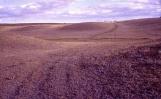
Harry Otterson on NWMP Trail of '82 - south of his old buildings
August 10, 1954
Climax, Saskatchewan, Canada
3
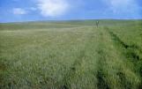
N.W.M.P.30 September 1961
Climax, Saskatchewan, Canada
4
NWMP south trail 1878 to 1882 - Clarence MartinSeptember 30, 1961
Climax, Saskatchewan, Canada
5
Plotting the Trail29 July 1961
Eastend, Saskatchewan, Canada
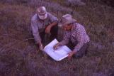
6
Plotting the NWMP Trail from the Bench to the river near old George Watson Ranch, MelBascom and Ted Aadland
July 29, 1961
Eastend, Saskatchewan, Canada
7
Planting Marker N.W.M.P. Trail3 July 1961
Shaunavon, Saskatchewan, Canada
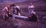
8
Planting NWMP Marker - north rim of the White MudJuly 3, 1961
Shaunavon, Saskatchewan, Canada