1
Oyster Pond, Nova Scotia: Then and NowThis album captures some of the earliest images of the village of Oyster Pond and compares them to the way the village is today. While many of the homes photographed in 1915 remain, many of the industrial buildings (sawmills and workshops) are now gone. The open landscape of the 1900s has also changed; cleared land is now overgrown by pasture spruce.
2
Detail map showing the location of Oyster Pond and the village store29 October 2004
Nova Scotia, Canada

3
Oyster Pond is a small coastal community on the Eastern Shore of Nova Scotia, located about 43 kilometres east of Halifax.Oyster Pond is one of four communities that surround Jeddore Harbour. The other communities are East Jeddore, West Jeddore and Head Jeddore. While East and West Jeddore were primarily fishing communities, Oyster Pond took advantage of the inland waterway and short portage known as the "Carrying Place" that connected it to the community of Upper Lakeville and the forestry industry around Lake Charlotte.
In the late 1800s, and early 1900s, several sawmills in the area made use of the abundant lumber being cut inland. Logs were boomed down Lake Charlotte, brought across the Carrying Place on a wooden "railway", and discharged into Oyster Pond, where they were boomed down to the mill. Ships coming into Jeddore Harbour could be loaded from there. Later, in the 1930s, pulp wood loaded onto large steamships moored in Jeddore Harbour, brought a much needed boost to the economy.
The easy access to Lake Charlotte also made Oyster Pond a good departure point for hunting tours. Nearby inns, such as Salmon River House (still operating today), kept boats at Oyster Pond for visiting hunters who would accompany local guides to their camps "up the lake".
4
The view of Jeddore Harbour from Oyster Pond10 November 2004
Oyster Pond, Nova Scotia

5
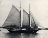
The Viola G. Hartlin at anchor in Jeddore Harbour1915
Oyster Pond, Nova Scotia
6
Cargo carrying schooners like this one were once common in Jeddore Harbour before trains and trucks replaced them in the late 1920s.7
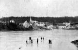
Skating on the pond, Oyster Pond, Nova Scotia1910
Oyster Pond, Nova Scotia
8
Skating was a popular pastime in Oyster Pond. The sheltered ponds provided good skating and access to an inland waterway which allowed skaters to visit the communities of Upper Lakeville and Lake Charlotte.Oyster Pond was a close knit community, as Doris Hutt recalls in this 2004 interview, reflecting on her childhood in the 1930s.
"There weren't a lot of cars. And all the kids would visit. And all the people, the people next door if they had an Aunt, they were our Aunt too. So if they had Aunt Irene, we had Aunt Irene. If they had Aunt Emma, we had Aunt Emma. And we visited just the same. We would gather as a group and visited all those people.
And I spent a lot of time especially on the pond skating. Sandy Myers who had a hotel or motel up where the Salmon River House is, he had boats at the Pond, at the bottom of the Pond. And we could use his boats. So we could row, any time we took the notion. Unless the sport people...in the spring the sport fisherman would have them. If there was a boat there you could help yourself to it."
9
St. John's Anglican Church with the 'pond' in the foreground8 November 2004
Oyster Pond, Nova Scotia

10
This is the same pond as shown in the previous photograph from 1915. Many of the homes visible in 1915 are still there, but obscured by trees.11
Sawmill of brothers Andrew and John G. Mitchell1910
Oyster Pond, Nova Scotia

12
In the early 1870s, brothers John George Mitchell (b.1841, d.1924) and Andrew William Mitchell (b.1836, d.1892) dammed the mouth of Oyster Pond in order to power their mill. This led to the death of the oyster beds which needed salt water flushing to thrive. The mill was in operation until about 1915.13
The remains of the dam used to power the Mitchell sawmills10 November 2004
Oyster Pond, Nova Scotia