1
The Tornado in the Midst of Boosterism2
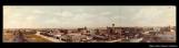
Panoramic view of Regina in 1911, the year before the tornado.1911
Regina, Saskatchewan
3
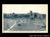
Victoria Park as it appeared before the tornado.1910
Victoria Park, Regina Saskatchewan
4
At the time of the tornado many Western Canadian settlements competed with one another for investment dollars and new inhabitants. This occurred through sophisticated advertisement campaigns in eastern parts of the country and elsewhere in the world.Cities such as Regina were touted as places destined for greatness, where countless opportunities waited to be seized - where the future was as bright as the imagination could bring dreams to life.
5
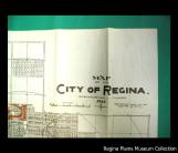
Regina City map detail.1912
Regina, Saskatchewan
6
The civic leaders who promoted the towns and cities of the early 20th century Canadian West were called Boosters. Together, the mayors, developers and other business advocates who touted their respective urban centre as the Dominion of Canada's next economic focus point, took part in a movement widely known as Boosterism.Boosterism has been described as an epidemic at the time, as elected officials and businessmen often made extravagant predictions in the hope of attracting new residents and inflating real estate prices.
7
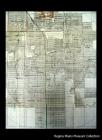
Regina City map detail. The hand is pointing at the industrial area of the city.1912
Regina, Saskatchewan
8
Developers often produced their own maps of the city. Using the Post Office as the chief landmark point, these maps allowed prospective residents to get a sense of the lay of the land. Concentric circles at one-mile intervals from the Post Office conveniently provided a frame of reference between commercial and residential districts.Bear in mind that most people at the time were still traveling by foot to get around the city.
9
Regina City map detail.1912
Regina, Saskatchewan
10
The maps made the city attractive in subtle ways. For instance, they were not drawn exactly to scale. Streets were wider than reality, giving the impression of ample space - of a certain distinctive character having been imparted to urban landscape design. One such map of Regina in 1912 already shows where the Albert Park neighbourhood would be developed. Albert Park was not annexed to the city until the 1960s.11
Regina City map detail.1912
Regina, Saskatchewan
12
By 1912, Regina was not only booming in terms of its image, it was really moving. It had is own municipally owned street railway; arteries were lined with electric streetlights - there was indeed a power plant. There were extensive waterworks and a drinking water supply apparently large enough for a population of 100,000. New works were already under construction that would increase the supply to 10 million gallons daily, which would be sufficient for a population of 150,000, the map information claims.A brand new $200,000 Parliament building had just been completed. A few years earlier, a $200,000 City Hall and a $300,000 Post Office had also been built downtown.
There were 250 wholesale and manufacturing organizations employing 1,200 commercial travelers in Regina, shipping in 1911 goods to the value of $40,000,000, according to the 1912 map of Regina insert.
Criss-crossing he city were 21 lines of railway operating or under construction.
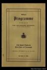
13
Programme for the Royal Visit in October of 1912.October, 1912
Regina, Saskatchewan
14
There were 46,000 people living in Regina on October 1st, 1912, according to the map information. This was 16,000 more than in 1911 and 40,000 more than in 1906.Twelve chartered banks operated in the city. There was $30,000 worth of agricultural implements shipped from Regina in 1912. Promoters claimed it was the largest amount of any point in the world. They also claimed the number of automobiles per thousand people in Regina was the highest of any city in Canada - obviously a true measure of urban prosperity.