1
Impact on Patterns of Mobility Within the City2
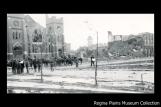
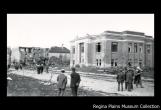
Tornado damage and horse team cleanup crews, as seen from 12th Avenue and Lorne Street.1912
12th Avenue and Cornwall Street, Regina, Saskatchewan
3
One of the most fascinating angles to concentrate on in the study of available tornado photographs is the exploration of how Regina residents seemed to react as they discovered the extent of the damage.Based on current theories of spatial perception, it is likely the tornado transformed the built environment in the affected areas in a way that required residents to temporarily develop a new mental map of their home neighbourhood. This is called a cognitive map in the anthropological and phsychological realms.
4
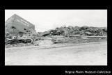
The ruins of the Winnipeg grain elevator1912
Dewdney Avenue, Regina, Saskatchewan
5
First of all, some of the landmarks one would normally use to get around or navigate through the city might have been destroyed or damaged by the tornado, and might not be as visible to the eye. These might be a particular house or any permanent structure tall enough that one would almost automatically rely upon it as a kind of beacon in the urban landscape.Theoretically, the longer one lives in the neighbourhood, the more familiar one becomes with the territory. The richer the landscape user's map also becomes, and less one relies on individual landmarks to find one's way.
6
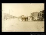
After the tornado at the corner of Smith Street and Victoria Avenue, looking south.1912
Cornwall Street and Victoria Avenue, Regina, Saskatchewan
7
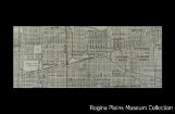
Detail from a 1912 map of Regina, showing the grid system and central location of the railroads.1912
Regina, Saskatchewan
8
We should also keep in mind that the layout of Regina is in classic grid fashion, with the C.P.R. railway line running roughly east and west; streets running north and south; and avenues running east and west. The city blocks thus created become landmarks themselves that are innately efficient in facilitating urban navigation. Just look at how today we give directions to people in Regina by telling them to go "a couple of blocks north and three blocks east", for example.As such the kind of street layout that makes up the city of Regina prior to the First World War is a fine example of efficiency when it comes to planning cities in which it is easy to find one's way.
However, Regina had welcomed many newcomers in the previous years who were equipped with a knowledge of the landscape that might have been thrown off by the impact of the tornado, at least for a while. It is likely a new, somewhat chaotic environment, might have altered perceptions of the urban landscape among these people, which might also have induced new patterns of mobility within the affected areas.
9
Regina City Police pass1 July 1912
Regina, Saskatchewan
10
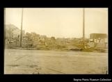
There was much debris strewn across the city's streets. Safe passage along back lanes was likely restricted because of ruined back buildings. In the midst of these urban arteries, nails, broken glass, splintered lumber and brick likely made travel hazardous at best.11
Several groups of pedestrians observe damage along Lorne Street.1912
Lorne Street, Regina, Saskatchewan
12
Keep in mind that most of Regina's inhabitants in 1912 moved around on foot. The streetcars had only been around for a year and the schedule was likely affected in the days after the tornado.How does one move around in such an environment? You can imagine it yourself. The process would be little different from that which you experience when you go for a hike over some unfamiliar terrain. First, you ask for directions from other people who might have already discovered which is the quickest, least perilous route to travel from place to place. This is generally how cognitive maps are created.
Next, you look for an established path to follow - one that seems to head in the general direction you seek. You look for the straightest route with the least obstacles, using clean, level walking surfaces and avoiding objects that might tear your clothes or have the potential to afflict wounds.
When one becomes familiar with the path, one's eyes rise off the ground and naturally start seeking new landmarks to rely upon as one moves around. This allows for the type of mobility that is more fitting in urban environments to take place - it allows for easier social interactions between citizens. With it comes a relative sense of normality in human relations in the landscape.
13
Damage from the tornado.1912
Regina, Saskatchewan
14
Obviously, post-tornado photographs suggest that in many places, the streets were still very accessible. An informed analysis might reveal that there are not many photographs of cluttered environments precisely because they were less accessible.There is little doubt that the impact of the tornado on the urban landscape engendered different patterns of mobility. Only further research would reveal the extent to which Regina citizens' perceptions were temporarily altered as a result.