1
Fire Insurance Plans Tell the Story of the 1912 Tornado2
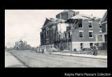
View of the First Baptist Church on Victoria Avenue shortly after the tornado.1912
Victoria Avenue, Regina, Saskatchewan
3
Fire insurance plans are one of the most useful resources when carrying out historical or achaeological research. They are plans of a built environment - a town or city - block by block. They constitute an actual footprint that is equivalent to an aerial photograph of a place, with the exception that these plans are hand drawn and associated to a specific scale.They were originally produced for fire insurance companies that would use the information revealed by them to set their rates for clients.
4
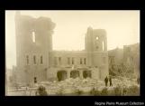
View of damage to the Metropolitan Methodist Church on Lorne Street after the tornado.1912
Lorne Street, Regina, Saskatchewan
5
They contain loads of information, like the type of occupancy or use of the buildings; the building materials used, each colour-coded according to type - whether it was wood, brick veneer over wood; brick, iron-clad over wood-frame, concrete or stone that was used for the structure.The plans reveal also many details of external and internal construction and architectural features. They inform viewers as to building height (number of floors); street widths and numbers, location of property lines; as well as whether or not there was a fence between lots.
As you can imagine, these plans would be extremely useful in terms of helping identify the location of water pipes or mains, fire hydrants and fire alarm boxes which would affect the insurance rates charged.
Through elaborate legends, they would tell those who consult them where boilers were located - hence where risk of explosion would be greatest. From an archaeologist's standpoint, fire insurance plans can be very useful in reconstructing past coal consumption patterns.
Boilers consumed much more coal than resdiential furnaces. Wood lots and coal storage sites were identified on fire insurance plans. Therefore local fuel usage practices could be derived from the study of fire insurance plans, and so on.
6
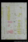
Detail from page 6 of the 1913 Charles E. Goade Fire Insurance Plan.1913
Regina, Saskatchewan
7
According to the University of British Columbia's Introduction to its Fire Insurance Plans of B.C. Cities website:"In 1875 Charles Edward Goade mapped Levis, Quebec, and later bought Sandborn's Canadian stock.()...() In 1917, Goade sold out to the Canadian and provincial underwriters associations. The associations amalgamated to form the Canadian Underwriters' Association in 1960 and subsequent production of fire insurance plans was centralized under the Plan Division of the Association. In 1974, the Association became the Insurers' Advisory Association. The following year, in 1975, production of fire insurance plans ceased."
The Saskatchewan Archives Board has copies of the 1911 City of Regina Fire Insurance Plans produced by civil engineer Charles E. Goade. It also has the 1913 edition. Where these two editions are extremely useful is in conducting research on the impact of the 1912 tornado, by comparing the two editions in areas that were affected by the tornado.
Theoretically, one could compare buildings in 1911 that were no longer there or shown as ruins in 1913, and figure out roughly the actual path of the tornado.
Interestingly enough, the Laird building, built in 1906, just on the east side of Smith Street, is listed as a two-storey concrete building on the 1911 Fire Insurance Plan, while by 1913, according to the updated edition of the plan, it has become a three-storey brick building. This suggests that it was quite possibly damaged by the tornado and rebuilt shortly after with an extra floor.
Above all today, the fire insurance plans constitute an accurate record of a built environment that has often disappeared from the contemporary landscape.
8
Text by Claude-Jean Harel, MA, MAHIPresident and Founder of the Great Excursions Company
www.greatexcursions.com