1
Edison - The Way It Was1980
2
A Note on SourcesIn the 1960s the Westlock Old Timers Society created a series of one-of-a-kind binders of photographs and anecdotes to illustrate the history of the region. These have been available for viewing at the library for years, and are now in the archive section of the Westlock & District Museum.
The photographs within are usually provided with short captions, but dates are rare, identities in the photographs occasional, and attribution of the source or creator scant. The text is occasionally attributed.
These bound records are The Westlock Story 1913-1963 and The Good Old Days 1867 � 1967. 80 Years of Progress, the Westlock History Book Committee publication provided further confirmation. Three sections specifically are MacGregor, J. G. Westlock area pre-settlement Days. Pp. Vi, Otto (Clark), D, The Early history of Edison settlement. Pp. 6 � 11 and Sterling, J. Edison School # 1029. Pp. 186 � 189 (ES1029-80YOP)
Pre-Homestead records for the metis and First Nations peoples were found in several references:
Cardinal, Phyllis (1997) The Cree people. Edmonton: Tribal Chiefs Institute of Treaty 6 and Duval House Publishing p. 19
Helgason, Gail (1987) The first Albertans: an archaeological search. Edmonton: Lone Pine Publishing
______ (1992) Kayas Kipohtakow. Morinville Ab: Kipohtakow Education Centre p 26)
The exploration record is drawn from Petty, Thomas (1962) Trails of Alberta. A Glenbow Foundation Project. Calgary; especially pages 99-104.
3
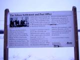
Highway sign for Edison settlementOctober, 2004
Edison, Westlock, Alberta, Canada
4
The Edison - Westlock area is now known as "Westlock and District" in central Alberta. Westlock is a short hour drive north of Edmonton Alberta in the heart of a productive mixed agricultural area. The town is at the intersection of Provincial Highways 44 and 18. The northern railway line of the Canadian National Railways to Slave Lake and the Peace River country also passes through this intersection of land routes.The historical marker for the Edison settlement is on Alberta Highway 18 westbound several kilometres east of Westlock, Ab.
5
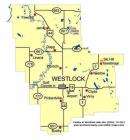
Westlock County Map2003
Westlock, Alberta, Canada
6
Edison predates Westlock as a settlement. Westlock was founded at the time the railway was built through the area in 1913, and this new community absorbed the original Edison community several kilometres to the east. Edison had been founded as a settlement a decade earlier when the Dominion Land Surveys opened the area to homesteaders in 1902.The present County of Westlock map shows communities within a half hour drive of Westlock, which is a one hour drive north of Edmonton.
7
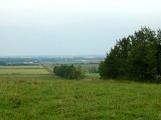
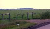
North from 'Protestant Hill' Environment of the Edison DistrictAugust, 2004
Edison, Westlock, Alberta, Canada
8
The story of "Protestant Hill"The region had just been opened for homesteads but near the base of the hill were three small houses where Joseph and Ferdinand Beauchamp and Euclid Leguerrier had already settled their families. Farther south of a rough cross marked the site of a future church and later the whole hill was taken by devout Canadiens.
And that is why Bill Mackay, not at all devout and as noted for his twisted jokes as for his great size, named it "Protestant Hill", the name it still bears.
(Garrison, D. Edison Settlement. Alberta Historical Review, Winter 1962)
9
Protestant HillAugust, 2004
Edison, Westlock, Alberta, Canada
10
Several views of the Edison district accompany this section. The first shows the shallow basin north from the summit of Protestant Hill.Protestant Hill is the local name for the height of land directly south of the Edison settlement. The view is from the northwest in the summer of 2004.
11
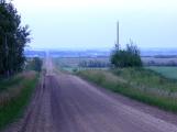
Range Road 261 NorthOctober, 2004
Edison, Westlock, Alberta, Canada
12
A well maintained rural road - Range Road 261 - now(2004) runs north to south over the summit of Protestant Hill to the broad valley of a tributary to the Redwater River where Edison Settlement began.13
Views from the northeast of Protestant HillAugust, 2004
Edison, Westlock, Alberta, Canada