1
Digby County is part of the Annapolis Valley between North and South Mountain, an extension of the Apalachian Mountain Range of New England. Its fertile soil and sheltered position made it ideal for settlement. Today the Valley is Canada's foremost fruit-growing region.2
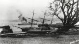
Cannon Banks1890
Digby, Nova Scotia
3
North of the Band Stand, on Water Street, is a row of cannons. These Victorian relics (and their Georgian predecessors) used to be, with the exception of one, from the west side of Digby Gap or Gut*, located to the right of the Fishermen's Wharf. At that time they and their site formed the area most recently known as the Cannon Banks/Robinson's Point. Before that it was called the Queen's Battery. In that earlier period they had a defensive function, namely to protect the town from American Privateers during the American Revolution up until the end of the War of 1812 when all hostilities between the two nations ceased.The Queen's Battery was operated by the local militia and used as a drilling area.
It was a little fort consisting of a blockhouse (20'x20') with a ditch and a drawbridge, surrounded by a circular parapet, or wall. In about 1794 there were five cannons, three 12-pounders and two 18-pounders. When the battery was remodelled in 1807 it was left with only two 12-pounders.
*Officially named St. George's Channel, it was first called "Teeweeden" meaning "Little Hole" by the Mi'Kmaq.
The beached three masted schooner seen in this photo was the John, a Norwegian wreck that was eventually burned to salvage her copper fastenings. The paddlewheeler ferryboat is the City of Monticello.