1
Map of Nova Scotia and Scotland20th Century
World map
2
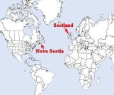
This map shows the distance between Scotland and Nova Scotia. It would take several weeks to make the voyage to Nova Scotia.3
Map of Scotland showing Barra20th Century
Scotland
4
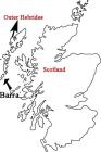
The islands that make up the Barra parish are located on the western side of Scotland and are part of what is called the Western Isles.5
Showing the major areas of Barra settlement1800-1840
Cape Breton Island, Nova Scotia
 Credits:
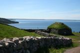
Pauline MacLean
6
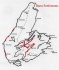
This map shows in red, the main areas where known immigrants from Barra settled. We have determined these major areas of settlement from oral history and from the petitions and land grants of the settlers.7
Landing of Barra people - re-enactment30 July 2002
Barra Strait, Cape Breton, NS
 Credits:
Rodney Chaisson
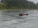
8
Once the settlers arrived in Nova Scotia, some used small boats to travel to areas they liked. This re-enactment of the first settlers to come to the Barra Strait, depicts the MacNeils who sailed the Bras d'Or Lake to find the place spoken about by Donald "Og" MacNeil and the best place to settle. They staked out the property and returned to Pictou for the winter. The next spring they came back to stay.9
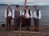
First settlers come ashore - Barra re-enactment30 July 2002
Barra Strait, Cape Breton, NS
 Credits:
Rodney Chaisson
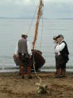
10
Re-enactment of Barramen's landing at the Barra Strait30 July 2002
Barra Strait, Cape Breton, NS
11
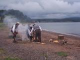
Building a fire30 July 2002
Iona, Victoria County, NS
12
Re-constructed blackhouse18 September 2001
Highland Village Museum, Victoria County, NS
 Credits:
Maria MacMillan
13
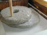
The settlers had lived in a stone building called a blackhouse in Scotland. They used a quarn or grinding stone to process their grain. Some also made a type of pottery called barvis ware which was fired in the peat fire.14
Quarn or grinding stoneCirca 1800
Highland Village Museum, Victoria County, NS