1
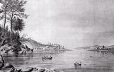
Erosional and deposit effects in Rift ValleyCirca 1976
North Eastern Ontario
 Credits:
Arrow North: The Story of Temiskaming
2
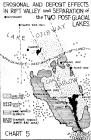
Pre-HistoryTen thousand years ago, the Temiskaming area was covered by a thick layer of glacial ice, more than one kilometre thick!
It took about 640 years before the major part of the ice sheet disappeared from the Lake Temiskaming area, leaving behind a deep lake, Lake Barlow-Ojibway. This lake was created by the remains of the glaciers to the north, preventing the northward drainage of the rivers to James Bay, as well as by a great mass of glacial debris blocking the southward flow of what is now, the Ottawa River.
As time passed, the northern ice melted while the outflow from the lake cut through the debris blocking its way south. In all, it probably took about two thousand years for the landscape to develop into its present state.
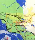
Eventually, this lake shrank so that it became two lakes with Lake Barlow covering what is now known as the Little Clay Belt.
The surface of the land would have been quite different from that of today, resembling the present-day tundra of our Canadian Arctic.
This subarctic landscape would have supported small trees and animals, typically caribou, and although there has been no trace of them to date, First Nations people are likely to have lived and hunted on this tundra.
3
The Little Claybelt in context of the larger Claybelt2006
North Eastern Ontario
 Credits:
Solar Wind Communications
4
Slowly, as the climate warmed and the ice melted from the tundra, the area as we know it today, appeared. This process was completed some five thousand years ago and coincided with a climate that was warmer than today. In fact, the climate became warm enough that, in the dry bed of Lake Barlow, (the Little Clay Belt), the vegetation growing there, was similar to that now found in southern Ontario!5
Representation of a first nation camp1500
North Eastern Ontario
 Credits:
Little Claybelt Homesteader's Museum
6
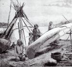
Shield-Archaic PeoplesThe Shield Archaic Peoples were widespread across what is now known as northern Ontario some five to six thousand years ago. These people originated to the south and west of the Ottawa River and may have come to the Temiskaming area in pursuit of their favourite animal, the caribou. It is suspected that they lived in wood-framed tents, presumably covered with animal skins or bark. As the climate warmed and the vegetation changed in the Little Claybelt, a new group of Aboriginal Peoples moved into the Temiskaming area.
This culture is called the Laurentian Archaic tradition. They appear to have migrated from the south and east, up the Ottawa River, finding ample food supplies in the Little Clay Belt area.Evidence shows that the Shield Archaic People lived in wood-framed tents, fished and hunted small mammals, and were the first people living in the Upper Ottawa area to use metal tools made from natural or native copper!
7
Spearhead2003
Lake Temiskaming, Ontario, Canada
 Credits:
Judy Martin
8
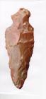
Laurel PeoplesThe Laurel Peoples cultural tradition (500 B.C.-500/900 A.D.) marks the first appearance of pottery in the Little Clay Belt region. Artefacts of clay pots and copper tools have been found at sites along major lakes and rivers (favourite camping areas) in the Lake Temiskaming region.
9
Late Pre-Contact and Historic First nations Peoples (A.D. 500/900-1600 A.D.)These peoples were groups who lived in northeastern Ontario just prior to the arrival of Europeans and European trade goods in what is now, Canada. Many of these groups are known on the basis of their pottery vessels and the distinctive decorations found on them.
Pottery traditions found in the Temiskaming area include Blackduck, Selkirk, and Ontario Iroquois. They are the direct ancestors of the present-day Ojibwa, Cree, and northern Algonquin Peoples, all of whom call themselves " Anishnabeg" which means "real people" or "human beings".
Late pre-contact Aboriginal peoples used stone tools and were skilled at making ceramic pots and other artefacts. The tradition of hunting small mammals and fishing continued. People lived in hide and bark tents and used birch bark canoes for transportation. Their camp remains have been found throughout the Upper Ottawa River and on Lake Temiskaming. It is believed that these pre-contact Peoples were probably related to today's Ottawa Valley Algonquin Peoples.
10
THE EXPLORERSThe French were the first Europeans to travel up the Ottawa River. Francois I commissioned the earliest French voyages of exploration in the 16th century to obtain a share of the New World's riches - goods that, up to that point, had been taken by Portugal and Spain.
The Ottawa River was the pathway for much of the early European exploration of North America. The most famous of French explorers in Canada will be remembered for their exploits and discoveries along the Ottawa River, beginning with Champlain and his emissaries who mapped and named many features of the river after founding Quebec in 1608. Nicollet, Radisson, La Verendrye, Dulhut, and De Troyes, travelled west along the Ottawa River, establishing trade relations with First Nations communities, laying the groundwork for the fur trade, a period that is central to the history of Canada.
11
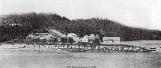
Hudson Bay Company Post1887
Lake Temiskaming, Ontario, Canada
 Credits:
C. A. Paradis
Temiskaming Shores Public Library Archives
12
FUR TRADE IN TEMISKAMINGOne of the New World's riches was fur, particularly beaver pelts. Europe's high demand for beaver fur, set in motion the development of an extensive fur-trading network involving both French and First Nations Peoples, then later, the British. This trading network quickly became the foundation of France's North American colonial economy and led to the cultural development of the now famous coureurs de bois and voyageurs era.
During the fur trade era, the Temiskaming First Nations People traded with both the British, who were well-established to the north on James Bay, and the French who had begun to establish posts at the Lake Temiskaming narrows. A French trade license from 1683, issued to the Sieur d'Argenteuil (a member of one of the most prominent families in New France) reported that he had brought down twenty canoes of furs from "Temiskamink" and "Tabitibi".
As the fur trade increased, the associated costs became so great that some of the traders, mainly French-Canadian voyageurs but also Scots, French, and English, decided to cooperate with one another in the 1770's forming the North West Company. It would exist under various forms for the next forty years, with principal forts at Chats Falls, Fort Coulonge, and Lake Temiskaming. The North West Company eventually amalgamated with its competitor the Hudson's Bay Company in 1821.
13
Fort Temiscamingue1876
Ville-Marie, Quebec, Canada
 Credits:
National Archives of Canada
14
FORT TEMISKAMINGFort Temiskaming was built between 1679 and 1685. It was the largest trading post on the Ottawa River built under the French. The fort was destroyed by the Iroquois and abandoned in 1688 and then reopened after 1720.
All other trading posts along the Ottawa River were subordinate to the Temiskaming Fort. For example, in 1755, 2% of colonial fur production passed through the fort, compared to 0.4% for Fort Frontenac. It also offset the British Hudson's Bay posts.
Fort Temiskaming is now a National Historic Site.