1
St. John's, pre- World War II, was the commercial centre of the then country Newfoundland, which relied on a resource based economy including sealing, fishing, mining and pulp and paper manufacturing. Life was slow-paced with each season methodically rolliing into the next and each harvest providing an abundant inventory for export. St. John's Harbour, a snug body of water hiding behind large rock cliffs, was the country's main port for trans-atlantic trade with vessels coming and going daily. Then in May 1941, the first ships of the Newfoundland Escort Force (NEF) arrived in St. John's and occupied the southside of St. John's Harbour. Overnight the city was transformed into a fast-paced major war-time port. St. John's would eventually become the home port for a significant portion of the Royal Canadian Navy, along with a number of vessels from the Allied navies.2
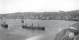
Two vessels from the White FleetCirca 1930
St. John's Harbour, Newfoundland
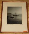 Credits:
A Ruggles Photograph
3
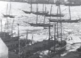
SS Susu with BuntingCirca 1910
St. John's Harbour, Newfoundland
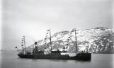 Credits:
CNS Photo 0305006
Memorial University of Newfoundland Geography Collection
http://www.library.mun.ca/qeii/cns/photos/geogfindaid.php
4
Marine transportation was the main means of importing and exporting goods to and from St. John's. Merchant vessels ranging from small wooden coastal schooners to large steel ocean going freighters made up the bulk of the harbour's traffic.5
View of the Narrows and Signal HillPost 1925
St. John's Harbour, Newfoundland
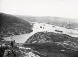 Credits:
CNS Photo 0303004
Memorial University of Newfoundland Geography Collection
http://www.library.mun.ca/qeii/cns/photos/geogfindaid.php
6
Two Steamers in the NarrowsPost 1900
St. John's Harbour, Newfoundland
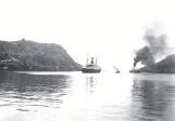 Credits:
CNS Photo 0303011
7
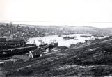
View of the Harbour St. John's from Signal HillCirca 1900
St. John's Harbour, Newfoundland
 Credits:
CNS Photo 0301016
Memorial University of Newfoundland Geography Collection
http://www.library.mun.ca/qeii/cns/photos/geogfindaid.php
8
Although a safe haven from the harsh Atlantic, St. John's was not immune to the pack ice that found its way down from the North. Oftentimes the harbour would freeze over and one could walk from the north side to the south side on the ice.9
Steamer Entering the Narrows, Houses and Flakes in the BatteryCirca 1900
St. John's Harbour, Newfoundland
 Credits:
S.H. Parsons and Sons
CNS Photo 0307002
Memorial University of Newfoundland Geography Collection
http://www.library.mun.ca/qeii/cns/photos/geogfindaid.php
10
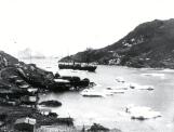
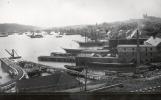
View of Vessels in Ice, Finger Pier including Southside HillsCirca 1900
St. John's Harbour, Newfoundland
 Credits:
CNS Photo 0305060
11
West End View of St. John's HarbourCirca 1920
St. John's Harbour, Newfoundland
 Credits:
CNS Photo 0301012
12
View from the Lower Battery with Fishing Skiff in ForegroundPre-1892
St. John's Harbour, Newfoundland
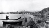 Credits:
CNS Photo 0301007
Memorial University of Newfoundland Geography Collection
http://www.library.mun.ca/qeii/cns/photos/geogfindaid.php
13
View from East End of St. John'sPre-1892
St. John's Harbour, Newfoundland
 Credits:
CNS Photo 0301004
Memorial University of Newfoundland Geography Collection
http://www.library.mun.ca/qeii/cns/photos/geogfindaid.php