1
Welcome to the Creston Valley, twenty-five miles long and up to eight miles wide, lying between the Selkirk and Purcell mountain ranges in the southeastern corner of British Columbia. Today, it is home to several small, thriving communities. The broad flood plain of the Kootenay River, which meanders north along the length of the Valley, is a patchwork of farmland, criss-crossed by fences and roads.It wasn't always like that.
2
The Creston Valley is one part of a vast network of rivers and lakes. The Kootenay River has its source high in the Rocky Mountains to the northeast. It begins by flowing south through the Invermere Valley, into Montana, then looping westward into Idaho before turning north to flow through the Creston Valley. It empties into the southern end of Kootenay Lake north of Creston, then drains the Lake, flowing west now, at Nelson. The Kootenay River meets the Columbia River at Castlegar, some sixty miles west of Creston.The Columbia River's source, Columbia Lake, lies in the Invermere Valley north-east of Creston. This river starts its journey heading north, making a great curve to the west at Golden and then flowing south, widening briefly into the Arrow Lakes north of Castlegar. Swelled by the waters of the Kootenay, it continues southward into Washington state before turning, once again, to the west and ending its journey at the Pacific Ocean at Astoria.
3
The camp of Louie Luke on the flats near West Creston.1928
West Creston, west of Creston, BC

4
For thousands of years, this region has been inhabited by the Ktunaxa (TOO-nah-ha) Indians. Their Creation Myth tells of a time when the two rivers, the Kootenay and the Columbia, were joined at a point in the Invermere Valley. A Wise Man built a dam at this point to trap and kill a water monster, and different parts of the monster became the different races of people: white, black, yellow, and red.From that time on, the two great rivers have been separate.
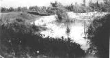
5
Showing the flood plains of the Purcell trench.1948
Creston Valley, BC

6
"We are in the Purcell Trench. Those are the Selkirk [to the west] mountains and those are the Purcells [to the east]. The original uplifting of the mountains, which was called orogenesis, when they came up the valley was V-shaped and you can't get a flood plain in a V-shaped valley because there's no room. There's just the river in the bottom and there's no room for anything else. There were several agents of land mass denudation or erosion and glaciation was the principle one. Anyhow, the glaciation changed this valley from a V-shape to a U-shape and that gave the river room to meander."- Bill Constable
7
Map showing the Creston Valley before any dykes were built.1900
Creston Valley, BC

8
Kootenay Lake and River formed about 12,000 years ago, when the last glaciers retreated from southern British Columbia. It drained to the south over a waterfall near present-day Bonner's Ferry, Idaho. The lake was held in place by an ice dam far down the Columbia River. As the ice dam melted, water levels in the Kootenay Valley dropped to a point where they were lower than the levels farther south, and the river reversed itself to flow north, as it does today.About 2,000 years ago, climatic shifts triggered the seasonal rise and fall of the Kootenay River, causing it to spill over its banks every spring and forming the broad delta that, today, is the Creston flats.
9
Flooding and natural growth that was common on the flats.1920
Creston Valley, BC
10
"Before Reclamation then, there were two rivers, the Kootenay and the Goat Rivers. There was dense growth on the river banks about a hundred fifty feet wide in places. Vines grew up all through it, you couldn't walk through it you had to crawl underneath it believe it or not. So, it was a tangle of cottonwoods, a jungle, a great cover for pheasants. There were countless sloughs, channels, potholes, lakes, meadowgrass, red topped rushes. We could skate actually from Creston to Wynndel. You would skate on one slough and go across the ridge and get on another and skate some more."- Bill Constable
11
A native woman by the name of Anastasia with her canoe at the edge of the flood waters.1928
Creston Valley, BC

12
The Ktunaxa fully exploited the resources available in this tangle of brush and network of sloughs. "We are Native people. We call ourselves Ktunaxa Native people. There are plenty of fish, ducks, and deer here. We also travel in our canoe, and our canoe is called sturgeon-nosed canoe."- Robert Louie
The canoe, ideal for use in the marshy areas of the Creston Valley, enabled the Ktunaxa to travel freely anywhere in their territory, whether during the spring floods or in late summer, when the receding waters would leave broad stretches of marsh land nearly dry.
13
Photo taken near Kootenay Valley road looking onto the flats before dyking.1920
Creston Valley, BC

14
"Why was it reclaimed? It was very rich soil. It was said to be second only to the richest in the world which is the Nile. Historically it's much easier to live on the valley bottom than on the mountain slopes. Everybody likes flat land and the soil's better, but, there is a danger of flooding."- Bill Constable