1
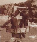
The Lighthouse Keeper scales the lighthouse to paint the outside20th Century
North-East Light, St. Paul's Island, Canada
 Credits:
The North Highlands Community Museum
2
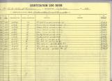
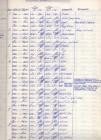
Sample page from 1977 log bookCirca 1977
St. Paul's Island, Nova Scotia, Canada
 Credits:
The North Highlands Community Museum
3
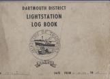
St Paul's Log bookCirca 1977
St. Paul's Island, Nova Scotia, Canada
 Credits:
The North Highlands Community Museum
4
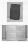
Log book from St. Paul's Island's LightkeeperCirca 1968
St. Paul's Island, Nova Scotia, Canada
 Credits:
M. J. Tanner/ John Morrison
The North Highlands Community Museum
5
Sample page from St. Paul's Island Lightkeeper's Log BookCirca 1968
St. Paul's Island, Nova Scotia, Canada
 Credits:
The North Highlands Community Museum
M. J. Tanner/ John Morrison
6
Excerpts from RADIO TRANSMISSION TRAFFIC Log BookCirca 1967
St. Paul's Island, Nova Scotia, Canada
Excerpts from RADIO TRANSMISSION TRAFFIC from Log Book, St. Paul Island 1967-1968 All messages received and transmitted, including weather and ice reports.
Archives MG 16, 2 File A
14 Dec. 67 - 18:15 Hrs. We have not received all our Christmas mail do to busy postal service would appreciate a mail delivery before Xmas if possible.
Loose packed winter ice 7/10 coverage in all directions to end of visibility, vis. 12 miles.
10 Jan. 1968 12:00 Hrs. We have presently had winds of 80 to 100 M.P.H. with freezing spray all station buildings covered several feet ice causing some damage, one guy wire broken on beacon tower and danger of falling through our storage tanks or striking new fog alarm. Spray still making more ice. Impossible to get Morrisson off station for past week. Snow freezing spray and strong wind since first Jan.
13 Feb. 68 Landing and road to light station covered with several feet heavy ice, also ice blocked in front of landing.
Clear skies visibility 10 miles light NW wind close packed winter ice 9/10 coverage in all directions.
07 July 68 19:15 Hrs. Overcast skies visibility 10 miles winds north-northwest 15 knots
Mackeral started schooling both sides of island yesterday and today.
28 Oct. 68 14:20 Hrs. Request transportation for wife and self to Sydney for necessary medical consultation as soon as possible. Expect to be going in hospital for very bad throat condition. Please advise. Have tried salt water gargles every three hours, no improvement. Have tried penicillin every four hours over 3 day period. No improvement.
05 Feb. 69 10:15 Hrs. Report on storm damage of Feb. 4 Tanner's and Morrisson's dwellings taken severe pounding by heavy sea causing shingles to be torn from roof on both dwellings and some damage to ceilings by leaks also basements flooded. End of landing torn away also fog alarm engine room flooded to small degree. Winds south to southwest 80 to 90 knots. Lasted several hours.
Credits:M. J. Tanner/ John Morrison
The North Highlands Community Museum
7
Logbook from Lighthouse keeper- Includes weather and ice reports from various lightkeepers that yearCirca 1967
Cape North, Nova Scotia, Canada
 Credits:
The North Highlands Community Museum
8
Lighthouse optic20th Century
Cape North, Nova Scotia, Canada
 Credits:
The North Highlands Community Museum
9
Instrument for measuring the tideCirca 1976
South West Light, St. Paul's Island, Nova Scotia
 Credits:
The North Highlands Community Museum
10
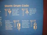
Storm Drum Code20th Century
St. Paul's Island, Nova Scotia, Canada
11
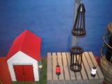
Storm drum model20th Century
St. Paul's Island, Nova Scotia, Canada
12
Notes on St. Paul's Island20th Century
St. Paul's Island, Nova Scotia, Canada
St. Paul's Island
St. Paul's Island lies in the Cabot Strait at the entrance to the Gulf of St. Lawrence. Actually two islands; the largest is about three miles long and from one quarter to three quarter miles at widest. It is separated from the smaller three acre rock by the narrow tide ripped channel called the Tittle. Early 16th century maps show only one island. This could be a geographer's error or the sea could have eroded the one clay seam in the otherwise granite island.
Since the earliest times this rocky desolate island has been a hazard to seamen entering or leaving the Gulf of St. Lawrence. The strong fast running tide in Cabot Strait, the almost perpetual spring fog, summer hurricanes, winter blizzards and drift ice have all contributed to the island's reputation as the "Graveyard of the Gulf".
There is not record of the first ship wreck, probably it was a Basgue fishing vessel bound for cod along the Cape Breton Shore. By 1810 north-eastern Cape Breton began to be settled, so news of wrecks trickled back to the mainland. In the early 1820's settlers along the shores of Aspy Bay would watch helplessly as the fires kindles by the survivors slowly died out, as one by one they died from exposure and starvation. Each spring when the ice had gone, the men would go to the island to burry the dead.
The earliest reported wrecks were the Viceroy of India and the Royal Sovereign. Both were troop ships during the war of 1812. Of the more than 800 aboard the Sovereign, only a handful survived to tell the tragic tale. However it was much publicized wreck of the "Jessie" in December, 1824 that the government of the day decided to take some action. The Jessie commerated by Jessie Cove, was wrecked on the south-west end of the island on December 25th, 1824. Her owner- Captin Donald McKay and his wife and his crew of 22 men manafed to get ashore but all perished during the winter. McKay kept a record of their ordeal. The last entry was March 17th, two and a half months after the ship wreck. A vessel from Cheticamp found the bodies in the spring- one salvager took McKay's richly made clock which was later recognized by his widow, and so the tragedy came to light.
In 1826, both New Brunswick and Nova Scotia set up separate life saving stations on the island . One on the western side at Petrie's Cove, the other on the Atlantic Cove or eastern side. Two men were supplies to each station.
These men and stations were sorely needed. In one night in 1835, four vessels life-saving crew more than 200 passengers had perished. However, over the years many otherwise doomed, seamen and passengers had cause to bless these men
In 1837 the British Government erected two lighthouses on the island, one at the south-west tip of the big island and the other on the smaller north-west rock. A life station was set up half way between the two stations. For the next three decades the life-saving crew criss-crossed the island twenty-four house a day.
The first keeper at the south-west light was John Campbell, a native of the Baddeck area. He continued as keeper and then superintendent for twenty-one years. He was followed by his son, Samuel C. Campbell, who served from 1858-1904, and by his grandson John Malcolm Campbell, from 1904-1919. In that year the latter was promoted to Governor of Sable Island. In all one family gave a total of 72 years continuous service.
A man named Donald Boone or Moon was the first keeper at the north-east light. He and his family moved to the small island in 1837. Nine years later, his two assistants saw a seal on the ice and deciding seal flippers would make a tasty dish, went out after it. The men got into difficulties, so Donald and a servant girl launched a boat to rescue them. None of the four were seen again. For four lonely nights his widow kept the light burning. Her plight was discovered when John Campbell came across from the big island.
If these light keepers were a special breed, so were their wives. For more than a century they left the comforts and companionship of the mainland to accompany their husbands into years of isolation. Their only contact with the outside world was the infrequent visits of the mail and supply boats or a fishing schooner stopping for water. They bore children, lost them and buried them there. We know of at least seven small graves; light keepers children at rest.
There were a few times when the population of the big island increases to 50 or more people. The life saving crews, light keeping families, and for a time a lobster factory crew. It was during this period (1895) that a school was established on the island.
The first clergyman to visit the island was Rev. John Murray, minister of the Falmouth Street, Presbyterian Church in Sydney and he began to pay yearly visits around 1880. At that time the four families connected themselves to the Falmouth Street church but by 1920 they were raised to the status of a congregation and the minister of Cape North was expected to spend at least one Sunday during the summer there.
Down through the years island life changed slowly. During World War two, the radio station and radar base was built on Cozan's Mountain; the highest peakon the island. Following the war, they were abandoned; as was the life saving station in earlier days. Finally only one light keeper and his assistant worked the south-west light. In the mid 60's this light because automatic, serviced by D.O.T. helicopter.
The north-east station continued as a manned station. Until the 70's three families lived there. When the fog horn was replaced by the beacon, the families dwindled to two. Finally all families were removed and the station became rotational. Men worked a 28 days on and 28 days off system.
13
Notes on St. Paul's Island20th Century
St. Paul's Island, Nova Scotia, Canada
Notes on St. Paul's Island
In August, 1897 Simon MacNeil from Ingonish was killed by a water spout or whirlpool.
On December 20th, 1955 George Gatza drowned with the boat swain't chair connecting the two islands broke as he was crossing the tittle.
O May 11th, 1961 a chopper crashed on the small island. No one was hurt.
On September 19th, 1961, a 7 foot kayak canoe paddled by ward Seeley, Thetford Mines, Quebec was forced to terminate on St. Paul's Island after paddling 1800 miles in 106 days, having left Montreal June 5th. Rough weather and exposure forced the termination.
September 12th, 1966
Pilot Dominic Lessitre and Felix F. Grasso from Schenectoby, New York 170 B were forced to land at Thrinity Cove when their plane ran out of fuel en route to Newfoundland. James Rogers's assistant keeper, northeast light, risked his life by Big Island. Effort made through V.C.O. to take them off failed, R.C.M.P. at Ingonish were contacted and on September 15th, the long-liner St. Therise out of Cheticamp sailed from Dingwall to tow the crippled plane to harbor.
Four other planes piloted by friends and relatives of downed fliers made forced landings on the same night. One landed in North Harbor, another at Bay St. Lawrence, the third reached Newfoundland while the forth was thought to have crashed in the mountains between Cape North and Cape St. Lawrence. An extensive air-ground search failed to fine any trace of the missing plane and its two occupants.
14
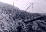
Crossing the "Tittle" from the north islet to the main island1923
St. Paul's Island, Nova Scotia, Canada