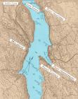
1
Strait of Canso showing the communities22 August 2004
Strait of Canso, Nova Scotia, Canada
2
DREAM OF A PERMANENT CROSSING - The dream and necessity of a permanent crossing at the Strait of Canso between mainland Nova Scotia and Cape Breton Island was in the hearts and minds of Cape Bretoners for many years. This very deep waterway with swift running tides, winds blowing fiercely down through the Strait and huge ice floes in winter, had always made it a challenge to cross from the time of the earliest settlement in the 1780's.3
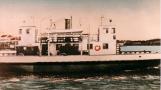
S.S. Mulgrave1895
Mulgrave, Guysborough County, Nova Scotia, Canada
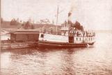
4
RAILROAD ARRIVES AT STRAIT OF CANSO - In 1880, the Intercolonial Railway arrived at Mulgrave on the mainland side of the Strait of Canso and in 1890, the railroad finally arrived on Cape Breton Island. The line was built between Point Tupper at the Strait of Canso and Sydney at the other end of the Island and by 1901, it was through to Inverness.The S.S. Norweigan followed by the S.S. Mulgrave had the task of ferrying the train cars across the Strait. The S.S. Mulgrave looked like a passenger boat. The train cars would go aboard tracks on a scow then the Mulgrave would hook onto the side of the scow and tow it across to the other side of the Strait. It was a precarious task and in winter a dangerous one.
5
Engineer's sketch of a proposed bridge for the Strait of Canso, 19031903

6
FIRST BRIDGE DESIGN - The Cape Breton coal mines were entering an era of development which ushered in the 20th century and many Cape Bretoners saw the need and wisdom of replacing the old fashioned ferry with a permanent crossing. In 1901, the Municipality of Victoria County made a resolution which recommended the construction of a bridge across the Strait of Canso.With the incorporation of the Canso Bridge Company in 1902 and the selection of a bridge design by Donkin and Waddell, a firm from Missouri, USA was brought in to conduct initial surveys at the Strait of Canso. This engineer's sketch shows the proposed bridge. With the American firm at the site, however, public support for the project lessened and eventually permission to construct the bridge was revoked.
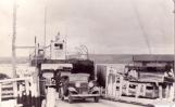
7
Point Tupper train ferry terminal1935
Point Tupper, Richmond County, Nova Scotia, Canada
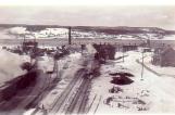
8
TRAIN CROSSINGS STATISTICS - The railway yard and ferry dock at Point Tupper on Cape Breton Island was a busy spot. The trains coming from what was referred to as Industrial Cape Breton where the coal mines and steel plants were had to be taken apart and pushed onto and off the train ferries for their trip across the Strait of Canso to Mulgrave on the mainland side.The same procedure occurred in Mulgrave to ferry trains across to Cape Breton."The volume of railway traffic transported by ferry boats has steadily increased from 40,000 cars a year in 1920 to an average of 113,000 cars each year between 1946 and 1950...By 1960 the estimated traffic per year might reach 145,000 cars"(Dept. of Mines andTechnical Surveys Geographical Bulletin No. 3, 1953)
9
The Pont de Canseau crossing the Strait of Canso circa 19261926
Strait of Canso, Nova Scotia, Canada
10
EARLY AUTO FERRIES - The first automobile ferries, too light and thin hulled to take the blows of the ice, were tied up and overhauled during the winter. It was only after the heavier ferries were introduced that year round ferry service for automobiles was offered.J. Alvin West of Port Hawkesbury who worked on the auto ferries in the Strait of Canso from 1934 to 1955 told Ron Caplan of the Cape Breton's Magazine,"Sometimes you couldn't make a straight course right across. You'd have to go down around, watch the ice pans. ....Captains would go if it was fit to go. Sometimes they took chances. Just had to.... "
11
The Sir Charles Tupper docks at Port Hawkesbury.1930
Port Hawkesbury Waterfront
12
PORT HAWKESBURY WAS THE GATEWAY TO CAPE BRETON for all of the auto traffic crossing to Cape Breton Island by the 1920's. In 1939, a Tourist Information Bureau was located just up from the ferry dock. There were stores, hotels and service stations on Granville Street to provide for the visitors needs."The tourist industry is one of the brightest spots in the economy of the Island; it is vital for it to have good roads and highways and a good system of crossing the Strait......"Tourism" depends almost entirely on the means of crossing the Strait". (Dept. of Mines and Technical Surveys Geographical Bulletin No.3, 1953)
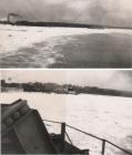
13
Ice in Strait of CansoMarch, 1947
Strait of Canso, Nova Scotia, Canada