14
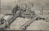
Southern Okanagan Lands Project workers pouring cement20th Century, Circa 1920's
Oliver, British Columbia, Canada
 Credits:
Johnstone, James Cameron
15
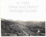
The area purchased for the lands project totalled approximately 22,000 acres of land, stretching from southern Penticton to the Canada- US border. Of this land, the Liberal government estimated that 13,960 acres could be irrigated at a total investment of $935,000.16
North view of valley prior to large-scale settlement20th Century, Circa 1920's
Okanagan Valley, British Columbia, Canada
 Credits:
Kelowna Photo Bank
17
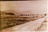
An inquiry by the Department of Industries under the Conservative government revealed that of the original 13,960 acres intended for irrigation, only 1270 acres were completed by 1923. At the beginning of 1924, 1381 acres of the purchased 22,000 had been sold to landowners.18
Picture of Highway 97 south of Oliver20th Century, 1910-1930
Oliver, British Columbia, Canada
 Credits:
Corbishley, Don
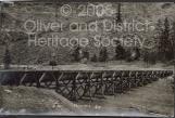
19
The geography of the valley was, in many places, unsuitable for in-ground construction of the ditch. Depressions in the valley, rocky terrain, and alluvial fans all represented impenetrable barriers. To overcome these obstacles, sections of the canal were built on raised flumes, carrying the water across until the project could continue in-ground.20
West Lateral Flume20th Century, Circa early 1920's
Oliver, British Columbia, Canada
 Credits:
Johnstone, James Cameron
21
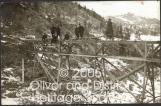
Construction workers were housed in tent camps along the canal. These, while inelegant, were relatively inexpensive and could be moved as the project progressed.22
Looking south-east over Engineer's Camp #43 January 1921
Oliver, British Columbia, Canada
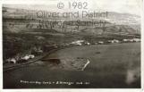 Credits:
Venables, Frank II
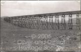
23
The initial estimated cost of $935,000 assumed an open-earth canal, and did not take into account the slowly rising cost of materials, nor the cost of flumes. A more thorough evaluation of the land suggested that an open-earth ditch would be unsuitable because the soil lent itself to washouts and water absorption. The project would require vast stretches of pipe and canalwork.24
Picture of Flume #220th Century, Circa 1920's
Oliver, British Columbia, Canada
 Credits:
Johnstone, James Cameron
25
Major engineering changes were made, including the addition of cemented canalwork and flumes, spillways, underground pipe, and an increased overall flow volume throughout the ditch. Many of these changes were made regardless of the increasing cost imposed. A reassessment of the construction costs estimated the project value at over $3.3 million; more than triple the original quote.To give an idea of the scale of this project, $3.3 million is approximately equal to $40 million in 2008; this does not factor in the increase in the cost of skilled labour or increased material costs.
26
Picture of Flume #320th Century, Circa 1920's
Oliver, British Columbia, Canada
 Credits:
Johnstone, James Cameron