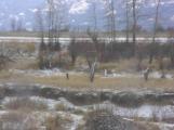
27
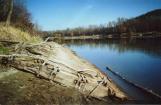
This is the discharge channel for the south end of the Reclamation Dyking District; the photo was taken from just above the concrete enclosure for the culverts. It was probably, many years ago, a channel of the Kootenay River, though some people we talked to believe it was dug, or at least widened, by the Alberta and British Columbia Exploration Company. Today, it spills into the marshy area known as French's Slough, which runs up the west side of Nick's Island and empties into the main channel of the Kootenay River.28
1941 Northwestern dragline21 November 2003
Reclamation Farm, near Creston, BC
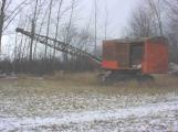
29
From the pumphouse, we continued south, driving across the original Piper farm. The Pipers were among the group of farmers that came to the Creston Valley in 1929, and stayed despite the recurring floods. Cyril stopped to show us this dragline, which was - and still is, occasionally - used for a variety of dyke construction and repair work throughout the Reclamation Dyking District. It's a Northwestern, similar to the machines that built many of the dykes throughout the Creston Valley.30
Rip wrap along the Kootenay River dykes.21 November 2003
Reclamation Farm, near Creston, BC
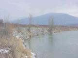
31
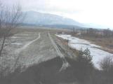
We turned onto Hanson Road, heading south-east along the top of Dutch's Ridge. This is the natural high ground that marked the southern limit of dyking in 1934, and connects with the dyke at the pumphouse we visited a few minutes earlier. Hanson Road leads onto a dyke along the west short of the Kootenay River, and Cyril stopped on this dyke to point out the rip-wrap: rocks piled up on the outside of the dykes, to prevent erosion of the dykes themselves. This, and another technique called set-back, are needed to counteract the more frequent fluctuations in the river since Libby Dam was built.32
Low water on the Kootenay River.April, 2002
Kootenay River, near Creston, BC
33
Cyril brought in this photo of the Kootenay River at low water. The ridges in the mud are caused by frequent fluctuations in the water level. Libby Dam, several times a year, will release water from its reservoir for a variety of reasons, and, although the rise is nowhere near the height of spring floods before Libby Dam was built, it causes enormous damage to the dykes. Each time the water rises, it softens the dykes, and when it falls, the softened walls slough away. Without the rip-wrap and set-backs, the dykes would be in very poor condition.34
Remains of a wooden barge alongside the Kootenay River south of Creston.April, 2000
Kootenay River, near Creston, BC
35
Somewhere along this dyke lie the remains of an old wooden barge, believed to be the floating office barge of the Alberta and British Columbia Exploration Company. It's only visible in very low water, so we were visiting at the wrong time of year to see it. Fortunately, Fred Ryckman took this picture of it in April 2000, when he and Bob Rogers made a special trip to find it.36
Looking east over Boundary Dyke21 November 2003
Boundary Dyke, south of Creston, BC
37
We headed west across the Valley again, rejoining Reclamation Road. At the south end of the Reclamation Dyking District, the road leaves the flats and climbs up the mountain side, offering this view of Boundary Dyke. The borrow pit, where dirt was scooped up to build and repair the dyke, is on the right side of the dyke.38
Englishman's Dyke21 November 2003
Reclamation Farm, near Creston, BC
39
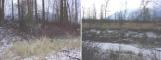
After a very bumpy drive along the power line, we came across the remains of the oldest dyke in the Creston Valley. This is Englishman's dyke, built in 1893 by the Alberta and British Columbia Exploration Company; the "Eng- lishman" was probably George Alexander. Although the dyke is in very poor repair - it is completely overgrown, and there are large gaps in it - it is still recognisable. The photo on the left was taken from the middle of the borrow pit just north of the dyke. The photo on the right was taken from on top of the dyke, looking south across Boundary Creek to Idaho, only a few hundred feet away.40
Looking south towards the dredging channel at Porthill.21 November 2003
Porthill, Idaho, USA